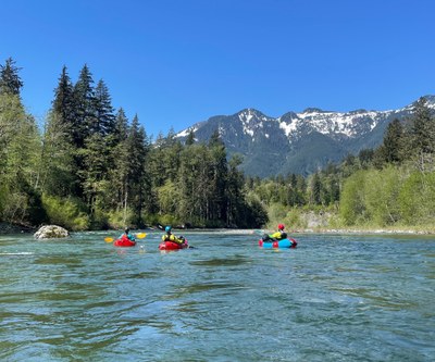
Snoqualmie River (Middle Fork - Upper Middle): MF Trailhead to Concrete Bridge
Also know as the Upper Middle Fork, this is one of the most scenic rivers to packraft. It is near North Bend and an easily accessible as a day trip from the Seattle area. The Class II rapids are not particularly difficult, but are fairly continuous.
FLOW
- NOAA Gauge: MF SNOQUALMIE--NEAR TANNER (TANW1)
- < 800 CFS: not recomended
- 800 - 1,200 CFS: low, runnable
- 1,200 - 2,500 CFS: runnable
- 2,500 - 3,500 CFS: pushy, runnable
PUT-INS
Take Exit 34 off I-90 and drive north on 468th Ave past the truck stop. In 0.5 miles, turn right onto Middle Fork Road. From here drive to one of three put-ins.
- Riverbend: For a shorter run, continue up the road to Road Mile 10.2 and a site known as Riverbend where the river nears the road at an unimproved camp site. There is room for 4 vehicles.
- Bridge View: This is the traditional put in. Continue to Road Mile 11.3 and a small pull-out along the river known as Bridge View, just before the turn into the Middle Fork Trailhead parking lot. There is only room for 2 vehicles here.
- Taylor River Bridge: This is the recommended put-in. There are a couple additional Class II+ rapids in the relatively narrow confines of the Taylor River. Continue up the road, past the vast Middle Fork Campground parking lot, to a pull-out on the right just before the Taylor River bridge. There is room for 4-5 vehicles.
TAKE-OUTS
Take Exit 34 off I-90 and drive north on 468th Ave past the truck stop. In 0.5 miles, turn right onto Middle Fork Road. From here drive to one of three take-outs that are encountered on route to the put-ins.
- Concrete Bridge at Granite Creek: This is the traditional take out and makes for a 10.2 mile paddle from Taylor River Bridge. Take Exit 34 off I-90 and drive north on 468th Ave for 0.5 miles. Turn right onto Middle Fork Road. Drive 5 miles to the Granite Creek Access (aka Concrete Bridge). Park in the large paved parking lot on the left side of the road. Walk 200 feet up the road to a gravel path and kiosk leading down to the river.
- Russian Butte: For a shorter trip, this site is 3 miles upriver from Concrete Bridge, at Road Mile 8. It is a short distance downstream of the Pratt River confluence. This access can also be used as a put-in for those who want to start their trip here and then continue down on the easier first section of the Middle Middle.
- Old Mine Creek Campground: For a slightly longer trip for paddlers who want some more action after the sleepy section from Russian Butte to Granite Creek. This is the easier beginning of the Middle Middle with some rapids that push Class III. This take out will add 1.5 river miles to the trip and is at Road Mile 3.5.
ON THE RIVER
Out of the gate there are two named rapids, Camp Brown Rapid (Class II+) and Rainy Creek Rapid (Class II+). There are a couple rapids that go right into headwalls. At higher flows, run these rapids far right to avoid the headwalls altogether. If you run the main wavetrains, avoid the instinct to try to paddle right at the bottom to avoid the headwall, because you will get stuck in a huge eddy line and likely flip. The halfway point is where Pratt River enters from river left. The action starts to taper off a bit after the Pratt River confluence, but stunning scenery rewards those who continue on downstream to Concrete Bridge at the Granite Creek confluence.
NOTES
- Trips can be 2 to 12 miles.
- It is possible to scout much of this section from the Middle Fork Road on the way to the put-in.
- For a longer day with more spice, this route can be done as a double header with the Middle-Middle Snoqualmie River run simply by continuing down the river if you are ready for some Class III rapids and a couple Class IV rapids.
- Learn more on American Whitewater's Snoqualmie, Middle Fork: 3 - Taylor River to Concrete Bridge (Granite Creek) (Upper Middle) web page.
- Suitable Activities: Packrafting
- Seasons: April, May, June, October, November, December
- Weather: View weather forecast
- Difficulty: Class II River
- Length: 8.0 mi
- Land Manager: Land Manager Varies
- Parking Permit Required: see Land Manager
- Recommended Party Size: 12
- Maximum Party Size: 12
- Maximum Route/Place Capacity: 12
- Green Trails Middle Fork Snoqualmie No. 174SX
This is a list of titles that represent the variations of trips you can take at this route/place. This includes side trips, extensions and peak combinations. Not seeing a title that fits your trip? Log in and send us updates, images, or resources.
- Upper Middle Fork Snoqualmie River
- Upper Middle Fork Snoqualmie River: Taylor River to Concrete Bridge
There are no resources for this route/place. Log in and send us updates, images, or resources.
