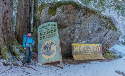
Monte Cristo, Glacier Basin, Silver Lake & Twin Lakes
Hike abondoned road along the South Fork Sauk River to the old mining town of Monte Cristo. Enjoy relics of the bygone mining era and return or continue on to Glacier Basin or Silver Lake and then Twin Lakes.
getting there
From Granite Falls, drive the Mountain Loop Highway ~30 miles to Barlow Pass where the paving ends (2,360 ft). Parking is on the left.
on the trail
monte cristo
Hike the abandoned road along the South Fork Sauk River to the old mining town of Monte Cristo. It's 8 miles round trip with 400 feet of elecation gain to a high point of 2,800 ft.
glacier basin
From Monte Cristo, head east to Glacier Basin. It's 12.5 miles round trip with 2,040 feet of elevation gain to a high point of 4,400 ft.
silver lake
From Monte Cristo, head south to Silver Lake. It's 12 miles round trip with 2,100 feet of elevation gain to a high point of 4,350 ft.
twin lakes
From Silver Lake, hike southeast to Twin Lakes. It's 17 miles round trip with 3,900 feet of elevation gain to a high point of 5,450 ft.
- Suitable Activities: Backpacking, Day Hiking
- Seasons: July, August, September, October
- Weather: View weather forecast
- Difficulty: Easy
- Length: 8.0 mi
- Elevation Gain: 400 ft
- 2,800 ft
-
Land Manager:
Mount Baker-Snoqualmie National Forest
Darrington Ranger District (MBSNF)
- Parking Permit Required: Northwest Forest Pass
- Recommended Party Size: 12
- Maximum Party Size: 12
- Maximum Route/Place Capacity: 12
- Green Trails Monte Cristo No. 143
- Green Trails Sloan Peak No. 111
- Green Trails Mountain Loop Highway No. 111SX
This is a list of titles that represent the variations of trips you can take at this route/place. This includes side trips, extensions and peak combinations. Not seeing a title that fits your trip? Log in and send us updates, images, or resources.
- Monte Cristo
- Glacier Basin
- Glacier Basin (Monte Cristo)
- Silver Lake
- Silver Lake (Monte Cristo)
- Twin Lakes
- Twin Lakes (Monte Cristo)
There are no resources for this route/place. Log in and send us updates, images, or resources.
