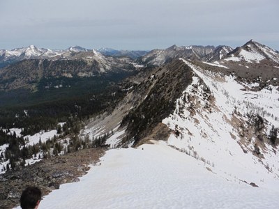
Mount Bigelow, Switchback Peak & Martin Peak
Known as the "Sawtooth Slam" this is a difficult and challenging scramble of three peaks in the Lake Chelan-Sawtooth Wilderness.
Getting There
Drive SR-20 past Twisp. After driving though Twisp turn south onto SR-153 and continue to Gold Creek Road. Drive Gold Creek Road (Forest Road 4340) to Forest Road 300 and follow it until near it's end. Park at the Crater Creek Trailhead (4,800 ft).
APPROACH
Hike the trail 6 miles to Upper Eagle Lake. Stay on the main trail and do not go on the side trails to Crater Creek or Martin Creek. Good camping is available at the lake (7,100 ft).
ASCENT ROUTE
Mount Bigelow
From the northwest side of Upper Eagle Lake ascend talus and snow, finding a way through cliff bands. Above the cliff bands turn right (north) and ascend talus, snow, and scree below the east face all the way to the northeast face where you are blocked by cliffs. The summit block will be on climber's left. "Follow your nose" to ascend Class 3 terrain (with exposure) about 100 feet to the summit.
Switchback and Martin Peaks
From Upper Eagle Lake take the trail to Horsethief pass and continue to Boiling Lake. Follow a trail up over a col on the south side of the lake and continue on Talus below Martin and Switchback Peaks, contouring between 7,200 ft and 7,300 ft. Either find a trail up the west face of Switchback Peak or climb the west ridge (Class 2-3). From the summit of Switchback, follow the long ridge to Martin Peak (Class 2-3).
DESCENT ROUTE
Descend the climbing route. One option if there is still snow is to descend the west face of Martin Peak diagonally towards the saddle above Boiling Lake. This way is quite steep and will require good snow conditions, and careful footwork and use of an ice ax.
TRIP PROFILE
| SEGMENT | TIME (HR) | ELEVATION GAIN (FT) |
|---|---|---|
| Seattle to Trailhead | 4 | |
| Trailhead to Camp | 3 | 2,300 |
| Camp to Bigelow | 2 | 1,300 |
| Camp to Switchback | 4 | 1,200 |
| Switchback to Martin | 1.5 | 50 |
| Martin to Camp | 2-4 | -1,200 |
| Camp to Car | 2.5 | -2,300 |
EQUIPMENT
Helmet, ice ax, crampons.
NOTES
- The road may not be open before late May.
- Suitable Activities: Scrambling
- Seasons: Year-round, May, June, July, August, September, October
- Weather: View weather forecast
- View avalanche forecast.
- Difficulty: Strenuous 5, Technical 5
- Length: 22.0 mi
- Elevation Gain: 7,600 ft
- 8,440 ft
-
Land Manager:
Okanogan-Wenatchee National Forests
Lake Chelan-Sawtooth Wilderness
- Parking Permit Required: Northwest Forest Pass
- Recommended Party Size: 6
- Maximum Party Size: 12
- Maximum Route/Place Capacity: 12
- Green Trails Prince Creek No. 115
- USGS Martin Peak
- Green Trails North Cascades Lake Chelan No. 114SX
There are no resources for this route/place. Log in and send us updates, images, or resources.
