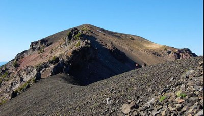
Mount Bailey
A challenging trip that is mostly trail hiking with easy scrambling along the final half mile. It's 10 miles round trip with 3,100 feet of elevation gain. Mount Bailey is a major peak west of Mount Thielsen near Diamond Lake in Oregon's central Cascades. There are interesting volcanic features including a hidden crater and a natural rock arch along the summit ridge that frames Mount Thielsen.
getting there
From Roseburg, OR, drive OR-138 (Northeast Diamond Lake Boulevard) east to Milepost 80. Turn left (west) onto Forest Road 4795, the north entrance to the Diamond Lake Recreation Area. Drive 3.5 miles along the east side of the lake to its southeast end and turn right to continue on Forest Road 4795. Drive 1.5 miles, turn left onto Forest Road 4795-300, and continue 1.3 miles to the trailhead.
on the trail
The trail begins on a flat covered by lodgepole pine. From there travel through open stands of mountain hemlock and true fir, reaching the timberline about 1 mile from the summit. The last half mile is steep and rocky.
- Suitable Activities: Day Hiking, Scrambling
- Seasons: July, August, September, October
- Weather: View weather forecast
- Difficulty: Strenuous/Very Strenuous, Strenuous 4, Technical 1
- Length: 10.0 mi
- Elevation Gain: 3,100 ft
- 8,369 ft
-
Land Manager:
Umpqua National Forest
Mount Thielsen Wilderness, Diamond Lake Ranger District (UNF)
- Parking Permit Required: Northwest Forest Pass
- Recommended Party Size: 8
- Maximum Party Size: 12
- Maximum Route/Place Capacity: 12
- Umpqua National Forest Recreation Map
- USGS Pumice Desert West, OR
- USGS Diamond Lake, OR
There are no resources for this route/place. Log in and send us updates, images, or resources.
