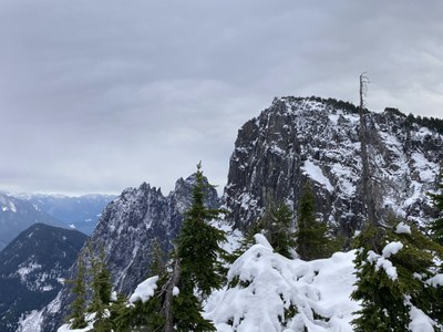
Mount Persis
Mount Persis is a moderate snow and/or rock scramble with 2,800 feet of elevation gain in a little over two miles. The final ridge line and summit offer wide views of the west flank of Mount Index and the valley of the Skykomish River.
Getting There
Drive US-2 to Forest Road 62, east of Goldbar. Drive Forest Road 62 taking the left fork each of two times when the road forks. Find unmarked boot trail about 100 feet from end of road. Vehicles without four-wheel drive and high clearance may want to stop at the big mud hole—this adds ~0.5 mile each way.
Approach & Ascent
Mount Persis (5,452 ft)
4.0 miles round trip with 2,800 feet of elevation gain
difficulty: Strenuous 2, Technical 2 or Winter Scramble
The boot trail which follows the west ridge of Mount Persis is barely visible from the dirt road and small parking area. Hike it as it ascends steeply in an easterly direction through newly planted trees, with mud, roots and rocks to negotiate. Once the main north-south ridge of Persis is reached, traverse south, skirting below Point 5017 and then reach a flat area with tarns. Pass below the summit and ascend to the summit from the south.
Mount Persis (5,452 ft) & Mount Index (5,979 ft) Traverse
12.0 miles with 6,000 feet of elevation gain
difficulty: strenuous 5, technical 5 OR Basic Alpine Climb
Follow the approach for Mount Persis above, and then descend the ridge to the south, dropping off the ridge to the west after the trees encroach on the ridge. Pass a prominent westerly buttress then south easterly to tarns at 5,200 ft and good camping. Follow a climbers’ trail and some cairns after the first large tarn up the slopes around Point 5308. The boot path becomes indistinct after the heather and steep vegetated slopes. Proceed just north of Point 5212 down over a rock step and toward climber's right (a hand line might be useful at this point). After the saddle at 4,900 ft ascend the ridge (snow in early season snow and scree later in the season) toward a rock band at climber’s left, up a Class 2/3 gully to its top, and then easy heather slopes to the summit.
Recommended Equipment: helmets, scramble rope, and crampons for early season.
Notes
- Under snow conditions stay back from the ridge top and north side as large cornices may exist.
- If it is not possible to drive to the trail head because of snow or the condition of the road, the distance and elevation gain are considerably more, depending on where you park.
- Suitable Activities: Climbing, Scrambling
- Climbing Category: Basic Alpine
- Seasons: Year-round
- Weather: View weather forecast
- Difficulty: Strenuous 2, Technical 2, Winter Scramble, Basic Alpine Climb
- Length: 4.0 mi
- Elevation Gain: 2,800 ft
- 5,464 ft
-
Land Manager:
Mount Baker-Snoqualmie National Forest
Skykomish Ranger District (MBSNF)
- Parking Permit Required: Northwest Forest Pass
- Recommended Party Size: 12
- Maximum Party Size: 12
- Maximum Route/Place Capacity: 12
- USGS Index
- USGS Gold Bar
- Green Trails Index No. 142
This is a list of titles that represent the variations of trips you can take at this route/place. This includes side trips, extensions and peak combinations. Not seeing a title that fits your trip? Log in and send us updates, images, or resources.
- Mount Persis & Mount Index Traverse
- Persis-Index Traverse
There are no resources for this route/place. Log in and send us updates, images, or resources.
