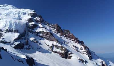
Mount Rainier/Ptarmigan Ridge
A classic 11,000+ foot technical climb on the north side of Mount Rainier up the Ptarmigan Ridge with a beautiful approach from the west via Mowich Lake or from the east via the White River Campground. The route includes spectacular glacier climbing on steep mixed snow, rock, and ice with a short rock pitch at over 12,000 ft.
GETTING THERE
White River Campground
Drive SR-410 in Mount Rainier National Park to Sunrise Road. It's 5 miles from the northern entrance and 4 miles from Cayuse Pass to the south. Turn onto Sunrise Road and drive 5 miles, turn left onto the White River Campground Road, and continue 1.2 miles to the campground (4,300 ft).
Mowich Lake
From Buckley drive south on SR-165, eventually crossing the Carbon River bridge, to a road junction with the right, uphill fork signed for Mowich Lake. Take this right fork all the way to the lake (4,929 ft).
APPROACH
The Mowich Lake approach route is shorter than the White River approach, but the Mowich Lake road often opens a few weeks later than the road to the White River Camp Ground. Also this climb is done as a carry over and the descent route goes down the Emmons Glacier and typically out the White River so a car shuttle would be required when starting from Mowich Lake. The approach to high camp is typically done in two days.
White River Campground
Hike 3.5 miles to Glacier Basin. Continue on the trail for another mile to base of the Inter Glacier ~6,000 ft. From here head southwest toward St. Elmo's pass up and out of Glacier Basin. From St. Elmo's pass (7,600 ft), descend onto the Winthrop Glacier traversing it between 7,200 ft and 7,400 ft to Curtis Ridge where there are good bivy sites. Next descend and cross the Carbon Glacier at 7,000 ft, then ascend to Ptarmigan ridge, following the ridge to the high camp at 10,200 ft, below the Ptarmigan Ice Cliffs.
Mowich Lake
Hike the Wonderland Trail for 4 miles up through Spray Park. Depart the trail here heading south east between Echo and Observation Rocks ascending the lower slopes of Ptarmigan Ridge. There are many good bivy sites along the way. Continue up Ptarmigan Ridge to the high camp at 10,200 ft. It is about 3.5 miles from the point leaving the Wonderland Trail to the high camp.
ASCENT ROUTE
From high camp descend quickly across the Mowich Glacier under the Ptarmigan (Liberty Cap) ice cliff run-out to the base of the route which is protected by a bergschrund. Find a way across the bergschrund near the rock outcropping at 9,800 ft. The route follows a rising traverse back east threading through the rock bands towards the Ice Cliffs up 45-50° snow or snow/ice for ~1,000 ft. Eventually the ramp reaches a steep rock band; traverse it east (climbers left) to the base of the hour glass. The traverse is exposed and should be protected with pickets and ice screws. Ascend the hour glass on either side up to the base of the large rock buttress.
There are two options here: (1) go east under the buttress out onto the Liberty Cap Glacier and up between the rock buttress and the ice falls climbing steep ice most of the way or (2) stay on the west side of the buttress climbing snow, rock, and ice pitches to an exit rock gully leading through the rock buttress to Liberty Cap (12,200 ft).
From Liberty Cap, head east towards the summit paralleling the bergschrund and eventually head southwest to cross the bergschrund and onto the top of the ridge. The route continues in a southeast direction following the ridge on wind-blown snow eventually trending in a easterly direction up the mountain. Follow the moderate glacier terrain to reach the summit at 14,100 ft.
DESCENT ROUTE
Descend the Emmons Glacier route.
TRIP PROFILE
| SEGMENT | TIME (HOURS) | ELEVATION GAIN (FEET) |
|---|---|---|
| Trailhead to Camp 1 | 5-8 | 3,300 |
| Camp 1 to High Camp | 5-8 | 3,500 |
| High Camp to Summit | 6-10 | 4,200 |
| Summit to Trailhead | 4-8 | -10,000 |
EQUIPMENT
Standard glacier gear, two ice axes or tools, crampons, pickets, ice protection (ice screws), small rack of rock gear.
NOTES
- This is a very strenuous technical climb, slightly more sustained than Liberty Ridge, that is typically done in 3-4 days.
INFORMATION FOR LEADERS
PERMITS
A climbing permit is required for trips on glaciers and/or above 10,000 ft. Fees apply. Check with Mount Rainier National Park (land manger link below) to be sure you have the required camping and climbing permits.
- Suitable Activities: Climbing
- Climbing Category: Intermediate Alpine
- Seasons: May, June, July
- Weather: View weather forecast
- Avalanche Terrain Rating Complex View avalanche forecast.
- Difficulty: Intermediate Mountaineering Climb, Intermediate Ice Climb, Intermediate Rock Climb
- Length: 20.0 mi
- Elevation Gain: 11,000 ft
- 14,100 ft
-
Land Manager:
Mount Rainier National Park
Mount Rainier Wilderness
- Parking Permit Required: National Park Entrance Fee
- Recommended Party Size: 6
- Maximum Party Size: 12
- Maximum Route/Place Capacity: 12
- Green Trails Mount Rainier Wonderland No. 269SX
- Green Trails Mt Rainier East No. 270
- Green Trails Mt Rainier West No. 269
- USGS Mt Rainier East
- USGS Mt Rainier West
There are no resources for this route/place. Log in and send us updates, images, or resources.
