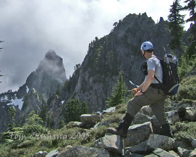
Mount Roosevelt & Kaleetan Peak
A challenging scramble near Snoqualmie Pass whether its just Mount Roosevelt or Roosevelt & Kaleetan. It's 12 to 14 miles and 3,500 to 5,200 feet of elevation gain. Together with a short car shuttle, delivers "two peaks for the "price of one."
getting there
Mount Roosevelt
Take Exit 52 off of I-90 at Snoqualmie Pass, and turn northwest onto Alpental Road and follow it to the Alpental parking area (3,100 ft).
Roosevelt & Kaleetan
Take Exit 47, Denny Creek off of I-90. Turn left over freeway and then right on Denny Creek Road (Forest Road 58). Just past Denny Creek Campground, about 3 mi from leaving I-90, turn left onto Forest Road 5830 and drive to the trailhead (2,300 ft). Leave some vehicles here and then proceed up the old Snoqualmie Pass highway to the Alpental Ski Area parking lot and the Snow Lake trailhead (3,100).
approach & ascent
Mount Roosevelt (5,835 ft)
Length: 14 miles round trip, Elevation Gain: 3,500 ft
Hike the Snow Lake trail to and around the lake to the junction with the Gem Lake trail, follow the latter to the southwest corner of Gem Lake, then take the way trail up the steep, westward-trending ridge toward Mount Roosevelt (don't take the lower grade of the trail that heads more directly to Chair Peak Lake and Melakwa Pass).
Continue on the ridge (the east spur of Mount Roosevelt) to about 5,400 ft, then head up scree for about 100 feet, and continue west and up ~200 feet to the base of the route (~5,500 ft) on Mount Roosevelt's summit block. A west-trending gully turns north and up a steep, exposed section of dirt and heather (dangerously slick when wet or when covered with only a few inches of snow), which then gives access to the rocky summit. Descend the climbing route.
Mount Roosevelt (5,835 ft) & Kaleetan Peak (6,259 ft)
Length: 12 miles one-way, Elevation Gain: 5,200 feet
From the summit of Mount Roosevelt, descend the route to the scree basin and drop south down the steep, chossy gully that leads to the north shore of Chair Peak Lake (frozen year round most years). Pass the lake on its east shore (climber's left), then continue up the north or "back" side of Melakwa Pass. From the pass, turn right (west) and continue up and around a steep boulder field to the bottom of the "white ledges" beneath Kaleetan Peak's southeast shoulder. Head up and left over the shoulder and follow a way trail in the scree-field on Kaleetan Peak's south flank up to the steep, somewhat loose gully that gives access to the summit.
Descend the route (highly recommended over south ridge "outhouse" route) and cut back across to the larger boulders of the scree field below (south) of Melakwa Pass. Stay on these larger, more stable boulders and head for the north end of the small forested area above upper Melakwa Lake. Continue on boulders to the left (east) of the forested area or follow a way trail through the forest along and in the inlet stream which feeds the upper lake. Pass the upper lake on its left (east) and then south. Pass the lower lake on its right (west) shore. Cross south over the west-trending outlet stream and follow the trail southwest. Reach a trail junction soon. Head left and up toward Hemlock Pass. This will lead the party over the pass and then down through interminable switchbacks, scree fields, and forested sections to the Denny Creek "water slide" and then to the Denny Creek trailhead.
Kaleetan Peak/White Ledges (6,259 ft)
difficulty: strenuous 4, technical 4
Follow the Melakwa Lake Trail to the lake. Then follow the boot path around upper lake. Ascend up towards Melakwa Pass, turn northwest beyond ridge of trees and ascend white ledges to the skyline, and finally head north to summit gully. There is loose rock on the ledges and in gully.
Kaleetan Peak/South Ridge (6,259 ft)
difficulty: strenuous 4, technical 3
Follow the Melakwa Lake Trail to the lake. At outlet of the lake there is a scramble trail all the way to the final 120 feet. This route follows the ridge crest. It is a good return route, but remember to stay high on the ridge and do not drop into the basin on the east side.
FOr leaders
Permit information
As of 2017, the Snoqualmie Ranger District considers Mountaineers trips and courses to be "nominal use". Leaders should print and copy this designation letter to show rangers they may see on trail.
- Suitable Activities: Scrambling
- Seasons: May, June, July, August, September
- Weather: View weather forecast
- Difficulty: Strenuous 4, Technical 3, Technical 4, Technical 5, Basic Alpine Climb
- Length: 14.0 mi
- Elevation Gain: 3,500 ft
- 5,835 ft
-
Land Manager:
Mount Baker-Snoqualmie National Forest
Alpine Lakes Wilderness, Snoqualmie Ranger District (MBSNF)
- Parking Permit Required: Northwest Forest Pass
- Recommended Party Size: 12
- Maximum Party Size: 12
- Maximum Route/Place Capacity: 12
- USGS Bandera
- Green Trails Snoqualmie Pass Gateway No. 207S
- USGS Snoqualmie Pass
This is a list of titles that represent the variations of trips you can take at this route/place. This includes side trips, extensions and peak combinations. Not seeing a title that fits your trip? Log in and send us updates, images, or resources.
- Mount Roosevelt
- Kaleetan Peak
- Kaleetan Peak/East Face
- Kaleetan Peak/South Route
- Kaleetan Peak/South Ridge
- Kaleetan Peak/White Ledges
There are no resources for this route/place. Log in and send us updates, images, or resources.
