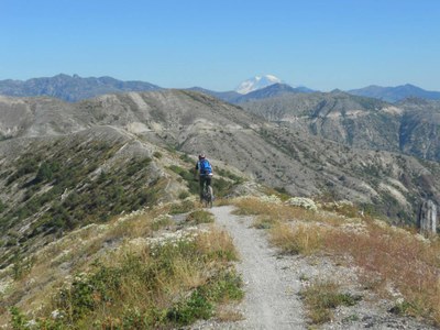
Mount St. Helens Loop
This loop connects mountain bike trails that feature diverse terrain on the east side of Mount St. Helens. Riders can choose among varied routes using the Ape Canyon, Plains of Abraham, Smith Creek, and Lewis River trails.
Getting There
Take Exit 22 off of I-5 and turn left into the roundabout taking the third exit onto Dike Access Rd heading east. Follow Dike Access Rd for 0.2 mile, where it curves right and becomes Old Pacific Highway. Stay on Old Pacific Highway for 0.8 mile, then take a slight left onto E Scott Ave for 0.2 mile. At the traffic circle, take the second left onto Lewis River Rd and drive 30.6 miles. Drive Road 90 for 0.8 miles continuing as Road 90 turns slightly right and becomes Road No 90 for 2.6 miles, then Forest Road 90 for 9.2 miles, and finally Highway 90 for 1.9 miles. Turn right onto 280 Road and drive 0.3 mile to the campground on the right.
On the Trail
Long Loop
79 mile loop, 12,000 feet of elevation gain, Difficulty: Very Strenuous
The route starts at Swift Forest Campground, connects to Forest Road 2588, the Ape Canyon Trail, the Loowit Trail, the Plains of Abraham, a 12 mi paved road segment, the Boundary Trail, Craggy Peak Trail, the Lewis River Trail, and ends on a 5 miles of paved road.
Difficulty: This is a very strenuous bikepack that links forest roads, blue, black, and double black mountain bike trails. There is nearly 12,000 feet of elevation gain over the route. It is not for the bikepacking beginner and should be attempted by experienced mountain bikers and bikepackers that are well conditioned, and prepared for significant climbing and hike-a-bike sections. The trail is 58% singletrack, and an estimated 97% of its 79 miles are rideable.
Camping & Water: Dispersed camping is available on much of the route. Badger Lake (Mile 43.5) is the recommended mid-route campsite, and water is available at Miles 12, 43.5, and 60-72 (along the Lewis River).
Short Loop
23-mile loop, 3,800 feet of elevation gain, Difficulty: Very Strenuous
Start at the Ape Canyon Trailhead and climb the Ape Canyon Trail to the Loowit Trail and the Plains of Abraham. Continue on the Abraham Trail to Windy Ridge, connecting to the paved road for a mile to Smith Creek Trailhead. Descend to the Smith Creek drainage and follow the Smith Creek trail into the Ape Canyon to the junction with Forest Road 83 Extension. Take this road to loop back to the Ape Canyon Trailhead.
Difficulty: This route, while significantly shorter than the long loop, it is still very strenuous and for experienced mountain bikers and bikepackers, because it includes steep climbing on singletrack, a steep descent on loose pumice, multiple creek fordings and many hike-a-bike sections.
Camping & Water: On the Plains of Abraham a reliable creek is found at Mile 5.4 after Pumice Butte. Camping on the Plains of Abraham would make sense if team had a late start but water availability is a concern beyond the main camping area at mile 5.4. Plenty of water can be found on the Smith Creek drainage from Mile 15 onward.
- Suitable Activities: Bikepacking
- Seasons: July, August, September
- Weather: View weather forecast
- Difficulty: Bikepacking MTB III, Bikepacking MTB IV
- Length: 79.0 mi
- Elevation Gain: 11,861 ft
- 5,291 ft
- Land Manager: Mount Saint Helens National Volcanic Monument
- Parking Permit Required:
- Recommended Party Size: 12
- Maximum Party Size: 12
- Maximum Route/Place Capacity: 12
- Green Trails Mount St Helens NVM No. 332S
| Name/Description |
|---|
| Mount St. Helens "Long Loop" Gaia GPS Track A link to the Gaia GPS bikepack route for the Mount St. Helens "Long Loop" (2020.08.22 MTB MSH Epic) by Emma Agosta posted Aug 22, 2020. |
| Mount St. Helens "Short Loop" Gaia GPS Track A link to the Gaia GPS bikepack route for the Mount St. Helens "Short Loop" (Ape Canyon/Plains of Abraham/Smith Creek Loop) by Emma Agosta posted Aug 27, 2014. |
| Ride with GPS Map A Ride with GPS map of the bikepack "Mt St Helen's Epic - MSHE" route posted on Sep 25, 2017. |
| bikepacking.com Data and maps for the Mount St. Helens Epic (Weekender) route on bikepacking.com. |
