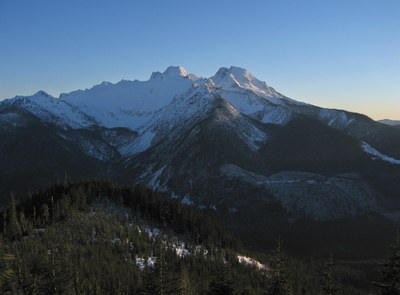
Stewart Peak
A moderate snowshoe with close up views of Mount Baker and the Twin Sisters Range.
Update 12/22/2021: This route is no longer feasible because of a large washout of Forest Road 3810 road ~3 miles from Forest Road 38. There is a steep drop-off on both sides of the washout making it unsafe to cross directly and the terrain above and below the road near the washout is very steep, making a detour extremely challenging, if not impossible.
getting there
From SR 9 or SR 542, turn east onto Mosquito Lake Road. Bear left at the fork onto Forest Road 38 up the Middle Fork of the Nooksack River. Shortly after crossing Clearwater Creek turn left onto Forest Road 3840 and drive as far as possible.
snowshoe route
Ascend the road to a spur road at ~3,200 ft. Take the spur road to its end at Point 4121. Ascend slopes to the west to the summit (4,320 ft).
Notes
- The true high point is the 4,320-foot closed contour rather than the 4,263-foot surveyed point to its west.
- Suitable Activities: Snowshoeing
- Snowshoeing Category: Intermediate
- Seasons: January, February, March, April, November, December
- Weather: View weather forecast
- View avalanche forecast.
- Difficulty: Moderate
- Length: 8.0 mi
- Elevation Gain: 2,000 ft
- 4,320 ft
-
Land Manager:
Mount Baker-Snoqualmie National Forest
Mount Baker Ranger District (MBSNF)
- Parking Permit Required: Northwest Forest Pass
- Recommended Party Size: 12
- Maximum Party Size: 12
- Maximum Route/Place Capacity: 12
- USGS Canyon Lake
- USGS Groat Mtn
There are no resources for this route/place. Log in and send us updates, images, or resources.
