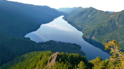
Mount Storm King
A strenuous, 3.8 mile round trip day hike with 1,700 feet of elevation gain. The trail goes through old-growth forest to a series of viewpoints overlooking Lake Crescent and the central Olympics. Continuing on to the summit is a steep, exposed, and challenging scramble. Another option for those seeking challenge is the grand traverse that is a loop from Barnes Creek up to Lookout Dome over to Mount Storm King and back down to Barnes Creek.
getting there
Drive US-101 to the Storm King Ranger Station on the south shore of Lake Crescent, 20 miles west of Port Angeles.
on the trail
Mount Storm King Trail (2,400 ft)
a strenuous 3.8-mile round trip hike with 1,780 feet of elevation gain
Hike the Barnes Creek-Marymere Falls Trail for 0.6 mile and turn left onto the Storm King Trail. It is nicely maintained trail under old growth canopy that ascends steeply as it works it's way above Barns Creek Valley and Crescent Lake. There are several good look-outs along the way. In 0.9 mile from the junction reach the first good view point (2,000 ft). From here a second viewpoint (2,400 ft), though not quite as good as the first, is another 0.5 mile and 400 feet of elevation gain. The trail officially ends here.
Scramble routes
Mount Storm King (4,534 ft)
Follow the Mount Storm King Trail as above. From the second view point (2,400 ft) scramble the ridge to the summit. This is a steep, exposed and challenging scramble.
Mount Storm King & Lookout Dome Traverse
17 miles with 6,000 feet of elevation gain and a high point of 5,100 ft
Hike the Barnes Creek Trail from the Storm King Ranger Station (0.0 mi, 617 ft). The trail follows Barnes Creek for four relatively gentle miles to the junction with the Aurora Divide Trail (3.9 mi, 1,500 ft). Take the left fork at this junction to continue on the sparsely maintained Barnes Creek Trail (expect blow downs and challenging route finding). The trail crosses Lizard Head Creek (6.1 mi, 1,830 ft), then crosses Happy Lake Creek at the site of an old camp (2,075 ft). The trail ascends a spur, then parallels the upper reaches of Barnes Creek. After crossing the stream, the path climbs sharply upward, then forks (9.1 mi, 4,800 ft). Take the left branch, to reach the summit of Lookout Dome (9.4 mi, 5,090 ft). For this last bit the trail switchbacks sharply to the base of Lookout Dome, then goes left around the rock’s base to ascend the easy back side to the summit. For those on a two day trip, the sunset and sunrise views afforded by a camp near Lookout Dome can be a real treat.
From Lookout Dome, scramble the various and numerous undulations of the ridge to reach the summit of Mount Storm King (13.0 mi, 4,534 ft). Continue scrambling ridge as it undulates. Follow a 310° bearing for 0.5 mile to a 4,250-foot bump, then a 232° bearing for 0.5 mile to a 3,750-foot bump, and then a 270° bearing for 0.5 mile to a saddle (14.5 mi, 3,100 ft). From this saddle, rather than continuing to a 3,150-foot bump, descend southwest to 2,900 ft, then traverse west, and then northwest to the remnants of the Mount Storm King Trail (15.0 mi, 2,900 ft). Descend the Mount Storm King Trail to its junction with the Barnes Creek trail (16.5 mi, 617 ft), and hike the last 0.5 mile to reach the Storm King Ranger Station (17.0 mi, 617 ft).
NOTES
- For the traverse, parties should be prepared to carry substantial amounts of water as there is very little (if any) on the ridge between Lookout Dome and the Storm King trail.
- Although the arduous scramble ascent/descent of Storm King is shorter using the Storm King trail for both directions, this strenuous scramble includes ~5,000 feet of vertical gain. By doing the traverse, this gain is spread out over two days with most of the gain on trail during the first day (with plenty of water sources), and the difficult scrambling on the second day after a good night’s rest.
notes
- A side trip to Marymere Falls makes nice addition to any of these trips.
- Suitable Activities: Day Hiking, Scrambling
- Seasons: April, May, June, July, August, September, October, November
- Weather: View weather forecast
- Difficulty: Moderate/Strenuous
- Length: 3.8 mi
- Elevation Gain: 1,700 ft
- 2,400 ft
- Land Manager: Olympic National Park
- Parking Permit Required: National Park Entrance Fee
- Recommended Party Size: 8
- Maximum Party Size: 12
- Maximum Route/Place Capacity: 12
- Custom Correct Lake Crescent - Happy Lake Ridge
- USGS Lake Crescent
- USGS Lake Sutherland
This is a list of titles that represent the variations of trips you can take at this route/place. This includes side trips, extensions and peak combinations. Not seeing a title that fits your trip? Log in and send us updates, images, or resources.
- Mount Storm King Trail
- Mount Storm King & Marymere Falls
- Lookout Dome Traverse & Mount Storm King Traverse
There are no resources for this route/place. Log in and send us updates, images, or resources.
