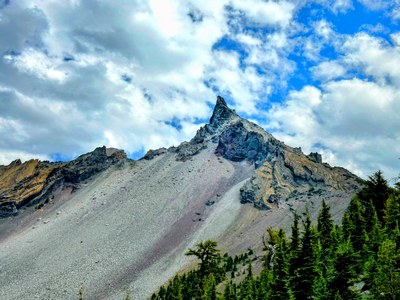
Mount Thielsen/West Ridge
A classic climb of the “Lightning Rod of the Cascades,” Mount Thielsen is known for its prominent summit horn. It is located in southwest Oregon just north of Crater Lake. It's one of the Cascade Volcanoes pin peaks.
Getting There
Take Exit 188 off of I-5 onto OR-58. Follow OR-58 to US-97 and turn south. From US-97 turn right onto OR-138 and follow it west and then north to the Diamond Lake parking area and Mount Thielsen Trailhead (5,450 ft).
Approach
Follow the Mount Thielsen Trail (No. 1456) ENE for 3 miles to the Pacific Crest Trail (PCT). Cross the PCT and take the climber’s path to the base of the summit horn.
Ascent Route
The summit can be attained via the west ridge (stay on ridge to minimize scree) or by traveling east then up the scree slope. Both end at a notch near the top of the south ridge. From the south ridge notch, circle around and up the final 80 feet on the east side. The rock is good, but there is little room on the summit.
Descent Route
Descend by the route you came up or use the alternate noted here.
notes
- Guidebook: Best Climbs Cascade Volcanoes by Jeff Smoot (Falcon Guides 2012).
- Suitable Activities: Climbing
- Climbing Category: Basic Alpine
- Seasons: April, May, June, July, August, September, October
- Weather: View weather forecast
- Difficulty: Basic Alpine Climb
- Length: 9.1 mi
- Elevation Gain: 3,302 ft
- 9,182 ft
-
Land Manager:
Umpqua National Forest
Mount Thielsen Wilderness, Diamond Lake Ranger District (UNF)
- Parking Permit Required: Northwest Forest Pass
- Recommended Party Size: 10
- Maximum Party Size: 12
- Maximum Route/Place Capacity: 12
- USGS Mount Thielsen, OR
This is a list of titles that represent the variations of trips you can take at this route/place. This includes side trips, extensions and peak combinations. Not seeing a title that fits your trip? Log in and send us updates, images, or resources.
- Mount Thielsen
There are no resources for this route/place. Log in and send us updates, images, or resources.
