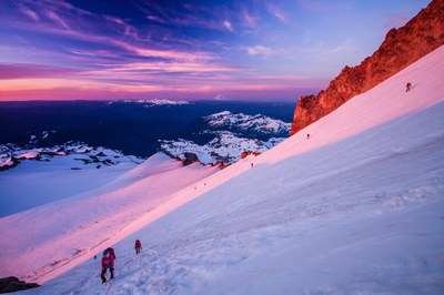
Mount Rainier/Tahoma Glacier
Mount Rainier via the Tahoma Glacier is Grade III with glacier travel on 30-45° slopes.
getting there
From SR-7 in Elbe, turn east onto SR-706, both known as the National Park Highway. Continue through the Nisqually Entrance of Mount Rainier National Park. Be prepared to pay the fee just after entering the park. One mile from the entrance, turn left (north) on Westside Road and drive to the gate (2,900 ft).
APPROACH
Hike up road approximately a half hour, to Tahoma Creek Trail. Ascend Tahoma Creek Trail and turn north on Wonderland Trail and ascend to 5,600 ft. Turn northeast on moraine to camp on the crest of Emerald Ridge between north and south lobes of the Tahoma Glacier at 6,100 ft.
Ascend a series of zigzags, initially ascending the southern side of the Tahoma Glacier to ~7,200 ft, then a gradual, diagonal traverse to the opposite side of glacier to ~9,000 ft. Continue traversing south again to near glacier side at ~10,000 ft, then back north towards other side. On this last traverse camp where it is safe from serac fall at about 10,440 ft, roughly parallel to Saint Andrews Rock.
ASCENT ROUTE
Finish last north traverse from Camp II to side of glacier, ascending seracs as required to cross crevasse moat to about 10,800 ft, then traverse south to about 11,000 ft. Turn and ascend north to about 11,200 ft to enter sickle. Ascend sickle on north side of glacier keeping left of icy ridges to a plateau at about 12,600 ft. Thence make a gradual rising traverse south to the summit cone.
DESCENT ROUTE
Descend via the Disappointment Cleaver route to Camp Muir and Paradise. Alternatively, descend the climbing route.
TRIP PROFILE
EQUIPMENT
Standard glacier gear, pickets and screws.
NOTES
- The Tahoma Creek Trail is closed due to flash flooding, but is passable. The flooding is due to sudden releases from the glacier. De familiar with warning sounds from the flooding and be prepared to seek refuge on high ground.
- The Tahoma Glacier is heavily crevassed with crescentric crevasses at the upper levels. Diagonal traverses and careful route finding are required.
- A carryover is recommended for both a quicker descent and to avoid sun weakened snow bridges on descent of the Tahoma Glacier.
- This route is best done in early season.
INFORMATION FOR LEADERS
PERMITS
A climbing permit is required for trips on glaciers and/or above 10,000 ft. Fees apply. Check with Mount Rainier National Park (land manger link below) to be sure you have the required camping and climbing permits.
- Suitable Activities: Climbing
- Climbing Category: Intermediate Alpine
- Seasons: May, June, July
- Weather: View weather forecast
- Difficulty: Intermediate Mountaineering Climb
- Elevation Gain: 11,330 ft
- 14,411 ft
-
Land Manager:
Mount Rainier National Park
Mount Rainier Wilderness
- Parking Permit Required: National Park Entrance Fee
- Recommended Party Size: 6
- Maximum Party Size: 12
- Maximum Route/Place Capacity: 12
- Green Trails Mount Rainier Wonderland No. 269SX
- USGS Mount Wow
- USGS Mt Rainier West
- USGS Mt Rainier East
There are no resources for this route/place. Log in and send us updates, images, or resources.
