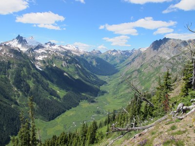
Napeequa Valley
The Boulder Pass and Little Giant Pass trails lead to the Naapeequa Valley, one of the most awesome, revered and wildest valleys in the state. The route to the pass is lined with flower-covered meadows, giant old growth trees and views of granite-spired Clark Mountain and the White Mountains.
getting there
boulder pass approach
From US-2 at Coles Corner, turn north onto SR-207. In 4 miles, bear left onto North Shore Road, continue 6.2 miles, and turn right onto Forest Road 6400 (White River Road). Drive 10.3 miles to the trailhead at the road's end (2,300 ft).
little giant pass
From US-2 at Coles Corner, turn north onto SR-207. In 4 miles, bear right onto Chiwawa Loop Road, continue 1.3 miles, and turn left onto Forest Road 62 (Chiwawa River Road). Continue 19 miles to the trailhead (2,600 ft).
On the trail
Napeequa Valley via Boulder Pass
Hike the Boulder Pass Trail to Boulder Pass (6,300 ft) and into the Napeequa Valley (4,400 ft to 5,000 ft) for a 37-mile round trip backpack with 6,500 feet of elevation gain, heading northwest along the river to Louis Creek or heading southeast long the river to reach Little Giant Pass for a longer trip. A trip to Boulder Pass is 23.4 miles round trip with 4,000 feet of elevation gain.
Napeequa Valley via Little Giant Pass
Hike the Little Giant Pass Trail to Little Giant Pass (6,400 ft) and into the Napeequa Valley (4,400 ft to 5,000 ft) for a 24-mile round trip backpacking trip with 6,400 feet of elevation gain. A day hike to Little Giant Pass is 10 miles round trip with 4,000 feet of elevation gain.
The trail up to Little Giant Pass is rugged. Brush and blowdowns can make for slower than expected travel if the trail hasn't been recently maintained. The trail from the pass down to the Napeequa is little-used, narrow, rough, eroded, and overgrown in places with serious exposure where a slip/trip/fall could be serious.
- Suitable Activities: Backpacking, Day Hiking
- Seasons: July, August, September, October
- Weather: View weather forecast
- Difficulty: Very Strenuous
- Length: 37.0 mi
- Elevation Gain: 6,500 ft
- 6,400 ft
-
Land Manager:
Okanogan-Wenatchee National Forests
Glacier Peak Wilderness, Wenatchee River Ranger District (OWNF)
- Parking Permit Required: Northwest Forest Pass
- Recommended Party Size: 6
- Maximum Party Size: 12
- Maximum Route/Place Capacity: 12
- Green Trails North Cascades Lake Chelan No. 114SX
- Green Trails Wenatchee Lake No. 145
- Green Trails Holden No. 113
This is a list of titles that represent the variations of trips you can take at this route/place. This includes side trips, extensions and peak combinations. Not seeing a title that fits your trip? Log in and send us updates, images, or resources.
- Napeequa Valley via Boulder Pass
- Napeequa Valley via Little Giant Pass
- Boulder Pass
- Little Giant Pass
There are no resources for this route/place. Log in and send us updates, images, or resources.
