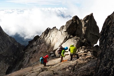
Goode Mountain/Northeast Buttress
Mount Goode via the Northeast Buttress is Grade III-IV, 5.4.
getting there
Take Exit 232 (Cook Road) off of I-5 at Burlington, turning east to Sedro Wooley and SR-20. Continue 47 mi to Marblemount for trip permits at Park Ranger Station. Continue to Rainy Pass, then descend east 2 mi from the pass to a large paved parking area, 4,400 ft.
APPROACH
Hike the Pacific Crest Trail south 10 mi to the junction with North Fork Bridge Creek Trail, 2,800 ft. Hike up North Fork of Bridge Creek, crossing Grizzly Creek. About 1/2 mile further the timber thins. Ford or cross a log of North Fork of Bridge Creek.
Beckey’s topo for the approach is accurate and useful. Ascend timber and scree to left of brushy lower slopes alongside leftmost watercourse draining from Goode Glacier. Ascend either the watercourse or, more likely, the slabs to the right. Bivy either in sparse timber at 5,200 ft or in rock bands east of buttress toe at 5,600 ft. Avoid regions close below active ice cliffs.
The alternate approach via Stehekan is no longer an attractive option due to washouts on the road above Highbridge.
ASCENT ROUTE
Here Beckey’s topo is out of date. From bivy site, ascend far left side of Goode Glacier then traverse glacier to left side of toe of Northeast Buttress. Gain crest of with two pitches of class 5 climbing., and is easier with higher access to the rock from the glacier. The crest of buttress provides the most aesthetic climbing. Halfway the buttress blends into the face and the climbing gets more difficult. Above, the buttress is again narrow and exposed with more low 5th class climbing, easing as the summit is neared. Good bivy sites near and on the summit. Drop packs for final ascent to summit then return and cross to Black Tooth Notch.
DESCENT ROUTE
Cross to Black Tooth Notch. Three single rope rappels gain class 3 terrain in the southwest couloir. When the couloir ends in cliffs, go left onto easier terrain then traverse back into basin below gully. Park Creek can be reached by descending a ridge that runs 240° from summit. Descend Park Creek trail to Stehekin River back to its junction with Bridge Creek for long return to Rainy Pass.
A descent can be made from the Goode/Storm King col directly back to North Fork of Bridge Creek. A double rope rappel may be needed to reach from the col to the glacier head wall. Two obstacles on the glacier will make this descent difficult in late season: 1). The burgschrund, which can be evaluated from the col. 2). A 50° ice slope which can be evaluated on the approach in North Fork Bridge Creek.
TRIP PROFILE
EQUIPMENT
Ice ax, crampons, standard rack, ice screws late season.
NOTES
Climb may be best after about third week of July, though accessing the toe of the buttress becomes increasingly difficult. One early July party reported high water crossings of Grizzly Creek and North Fork Bridge Creek difficult to find or suicidal. Other parties have found avalanche debris crossings available earlier in the season. Three to four days recommended.
- Suitable Activities: Climbing
- Climbing Category: Intermediate Alpine
- Seasons: July, August, September
- Weather: View weather forecast
- Difficulty: Intermediate Rock Climb
- Length: 37.0 mi
- Elevation Gain: 8,400 ft
- 9,200 ft
-
Land Manager:
North Cascades National Park
Stephen Mather Wilderness
- Parking Permit Required: None
- Recommended Party Size: 6
- Maximum Party Size: 6
- Maximum Route/Place Capacity: 6
- USGS McGregor Mtn
- USGS Goode Mountain
There are no resources for this route/place. Log in and send us updates, images, or resources.
