McMillan Spire/West Ridge
A strenuous climb in the Southern Pickets with 8,000 feet of elevation gain.
getting there
Drive SR 20 to Newhalem. Just east of Goodell Campground look for Newhalem Creek Road on the north side of the highway. Take the road to a T junction and turn left onto a gravel road. At the next fork take a right (uphill). Follow the signs to the group campground.
Approach
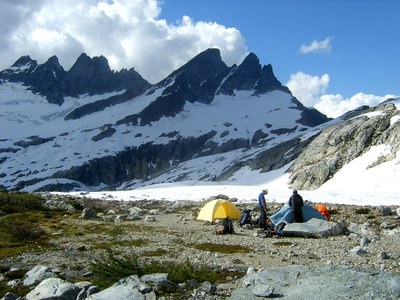
Goodell Creek trail is easily found behind a large boulder at campground. The trail is easy to follow and crosses two large streams which can flow high especially on hot days. Trail heads up at large cairn approx 4 miles in and climbs steeply (Seriously steep) to about 3,200 ft where it runs on top of a forested ridge. Easy to follow up to this point. Trail does a rising traverse to a very small talus field. Trail exits talus on left and does another rising traverse to a series of cliff bands. Follow close to, and stay below band following very faint trail. Find break in bands and enjoy some Class 3 root pulls for several hundred feet until above bands roughly 5,000 ft. This is where you exit the forest and must take note of this spot for the decent as it is the only way back into the forest. You may encounter some snow and moats here earlier season before continuing a rising traverse to the Terror notch which is due north from here, but not visible yet. Traverse moderate snow some of which had sketchy runout. The Notch had a 80-degree, 30-foot headwall at the top. From the notch descend scree slope 300 feet; it's pretty steep in some places so you need to be comfortable down-climbing. Reach a gravely, wildflower basin with a few streams roughly at 5,700 ft which offers the best camping spot.
Ascent Route
From camp, traverse along a few benches until you reach the outlet of a high glacial lake at approximately 5,550 ft. From the outlet climb rock and snow toward Terror Glacier below West McMillian Spire. Head directly up towards base of west ridge on West McMillian. Ascend the steep snow gully which turns into scree, heather, then more scree. Right below the summit block is a short bit of exposed Class 3 climbing
Descent Route
Ice axe and crampons.
Trip Profile
| SEGMENT | TIME (HR) | ELEVATION GAIN (FT) |
|---|---|---|
| Trailhead to Camp | 6,000 | |
| Camp to Summit | 2,000 | |
| Summit to Camp | 2,000 | |
| Camp to Trailhead | 6,000 |
Equipment
Standard glacier gear.
Notes
- Obtain water at the streams near 5,000 ft, because the last two miles is long and normally dry.
- Participants must be in extremely good shape and pack wisely (and lightly). The approach is steep and relentless.
- Suitable Activities: Climbing
- Climbing Category: Basic Alpine
- Seasons: June, July, August, September
- Weather: View weather forecast
- Difficulty: Strenuous 5, Technical 2, Basic Alpine Climb
- Length: 16.0 mi
- Elevation Gain: 9,800 ft
- 8,000 ft
- Land Manager: North Cascades National Park
- Parking Permit Required: None
- Recommended Party Size: 6
- Maximum Party Size: 6
- Maximum Route/Place Capacity: 6
- Green Trails Mt Challenger No. 15
- Green Trails Marblemount No. 47
- USGS Mt Challenger
- USGS Mt Triumph
- Trails Illustrated North Cascades National Park
There are no resources for this route/place. Log in and send us updates, images, or resources.
