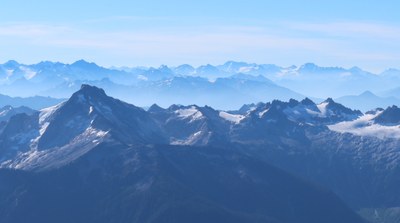
Mount Blum & Mount Hagan
Two seldom climbed peaks in the North Cascades near Mount Baker. Climbing either or both peaks is a long, and challenging trip.
GETTING THERE
From SR-20, turn north onto Baker Lake Road (Forest Road 11). Follow Baker Lake Road 26 miles to its end and the Baker River Trailhead (774 ft).
APPROACH ROUTE
Begin from the Baker River Trail at north end of lake. Hike about 10 minutes north, then cross Baker River on the bridge. Leave the trail about 175 yards downstream of the bridge (before Blum Creek) to find a path through old timber bearing away from the creek. Follow it or the forest slope eastward to the spur ridge north of Blum Creek. Make an ascending traverse along the south side of the ridge to just north of Blum Lakes (4,900 ft) and traverse easily to the two main lakes and good camping.
ASCENT ROUTE
Mount Blum/West Route—South Ridge
From upper Blum Lakes camp ascend a gully in rocky terrain connecting the lower lake to the 5,720 ft snow cirque lake to the southeast. From left of this lake’s headwall, turn northward and scramble a Class 3 gully. The gully traverses into heather slopes, which bear to a snow couloir heading toward the summit; the final south ridge is not technical.
Mount Hagan/Southwest Peak
From lower Blum Lake ascend southeast to 5,600 ft on east-west trending ridge. Traverse south roping up for the glacier to a pass between south and middle Hagan Peaks 6,831 ft. Ascend the south peak via its north side to a notch on its upper east side. Traverse on the south face, on the summit ridge; work up a spur on the east then bear around to the south where slabs lead to the summit (Class 3).
DESCENT ROUTE
Descend the climbing routes to Blum Lakes, then return to Baker River trailhead by way of approach route.
EQUIPMENT
Standard glacier gear and small rock climbing rack.
NOTES
- Because of the approach route this is a demanding climb. Participants must be in very good physical condition and willing to suffer some. This climb can be done in two long days by a fast group, however, a three day climb would be more enjoyable.
- This route starts in the Mount Baker-Snoqualmie National Forest and then passes through the Noisy-Diobsud Wilderness and into North Cascades National Park.
photo by rob busack
- Suitable Activities: Climbing
- Climbing Category: Intermediate Alpine
- Seasons: June, July, August, September
- Weather: View weather forecast
- Difficulty: Intermediate Mountaineering Climb
- Length: 13.0 mi
- Elevation Gain: 6,900 ft
- 7,680 ft
-
Land Manager:
North Cascades National Park
Noisy-Diobsud Wilderness, Mount Baker Ranger District (MBSNF)
- Parking Permit Required: Northwest Forest Pass
- Recommended Party Size: 6
- Maximum Party Size: 6
- Maximum Route/Place Capacity: 6
- USGS Mt Blum
- Green Trails Mount Baker Wilderness Climbing No. 13SX
- USGS Damnation Peak
- USGS Mt Shuksan
This is a list of titles that represent the variations of trips you can take at this route/place. This includes side trips, extensions and peak combinations. Not seeing a title that fits your trip? Log in and send us updates, images, or resources.
- Mount Baker
- Mount Hagan
There are no resources for this route/place. Log in and send us updates, images, or resources.
