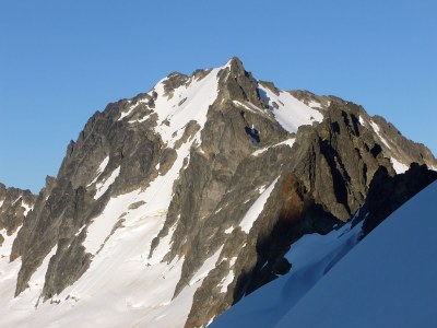
Mount Buckner/North Face
The North Face on Mount Buckner is a Grade II ice or snow climb.
DRIVING DIRECTIONS
Drive I-5 to exit 232 (Cook Road) at Burlington. Turn east to Sedro Wooley and junction of SR 20. Turn left and continue 47 mi to Marblemount for climb registration and trip permits at Park Ranger Station. From Marblemount take the Cascade River Road (Forest Road 15) for 22.9 miles to the Cascade Pass Parking Area.
APPROACH
Hike trail to Cascade Pass and then up Sahale Arm path to moraine flats, 7,600 ft. If not doing a carry-over, camp near the toe of Sahale Glacier in sight of Sahale Peak.
Ascend toward Sahale Peak up broad south facing glacier by bearing right on gentlest gradient to right side of upper slope. Work to the head of a shallow, steep, cruddy gully on right side of Sahale's pyramid and climb over the summit and down to the Boston-Sahale Col. Follow ridge of loose rock toward Boston Peak over several rock humps until an easy ledge system leads to Boston Glacier.
For a carry-over, camp on flats beneath Boston. After descending initial steep snow in direction of Buckner, a high line across glacier leads directly to base of face.
An alternate approach via Boston Basin Trail climbs to the Boston-Sahale Col via Quien Sabe Glacier.
ASCENT ROUTE
Work left of any bergschrund, back right to center of lower face and straight up until upper rock cliffs force several pitches leftward in a rising traverse. Within 200 ft of summit go left around a craggy-looking outcrop at end of upper cliffs then back rightward to gain the summit.
DESCENT ROUTE
Descend southwest face (gullies, scree, snow) on fall line to about 7,200 ft. Taverse down and right to cross cirque of Horseshoe Basin on broad ledge system (the middle one) at 6,200-6,400 ft (passing right near entrance to Davenport Mine) to a snow finger at same elevation. Ascend snow finger 100 ft to gain rounded ridge above ridge toe. Scramble 40 ft up steep rock steps then ascend 300 ft on paths through heather and rock on ridge crest keeping Davenport Glacier in sight most of the time. When ridge steepens, traverse up and left on slabs and snow above glacier debris to moraine flats beneath Sahale.
TRIP PROFILE
| SEGMENT | TIME (HR) | ELEVATION GAIN (FT) |
|---|---|---|
| Seattle to Trailhead | 3 | |
| Trailhead to Camp | 3-5 | 3,900 |
| Camp to Climb | 3-4 | 200 (net) |
| On Climb | 3 | 1,300 |
| Summit to Trailhead | 5-6 |
EQUIPMENT
4 ice screws & 3 pickets per team, crampons, ice axe, 2nd tool
NOTES
This route can be done with a camp on the Sahale Moraine or as a carry-over with a camp on Boston Glacier. With light packs, a carry-over will make for a much shorter second day. If camping on Boston Glacier, the Quien Sabe Glacier route to the Boston-Sahale col is more direct. Permits for the Sahale Moraine camp go very fast on summer weekends. The ranger will inspect the camp and give citations to parties camped there without appropriate permit.
- Suitable Activities: Climbing
- Climbing Category: Intermediate Alpine
- Seasons: July, August
- Weather: View weather forecast
- Difficulty: Intermediate Ice Climb
- Elevation Gain: 5,400 ft
- 9,114 ft
-
Land Manager:
North Cascades National Park
Stephen Mather Wilderness
- Parking Permit Required: None
- Recommended Party Size: 6
- Maximum Party Size: 6
- Maximum Route/Place Capacity: 6
- Green Trails Cascade Pass No. 80
- Green Trails McGregor Mtn No. 81
- USGS Cascade Pass
There are no resources for this route/place. Log in and send us updates, images, or resources.
