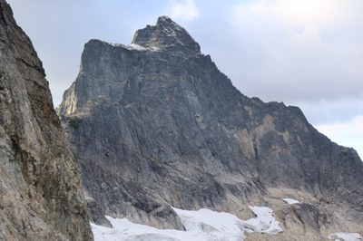
Mount Triumph/Northeast Ridge
The Northeast Ridge on Mount Triumph has a difficulty of Grade III, 5.5.
getting there
Drive I-5 to Exit 232 (Cook Road) at Burlington. Turn east to Sedro Wooley and junction of SR-20. Turn left and continue 47 miles to Marblemount for climb registration and trip permits at Park Ranger Station. Continue east 12 miles on SR-20 and take side road 5.3 mi to Thornton Lakes Trailhead, 2,700 ft.
APPROACH
Follow trail to lower Thornton Lake. Hike around west side of lake and follow right bank of stream to middle Thornton Lake, 4,400 ft. Make a high rising traverse around east side of lake and ascend long gully northwest (climber’s path in gully) to 5,750 ft col above lake. Good campsites at col, last with reliable water. An alternate bivy is located two pitches up Northeast Ridge. It has space for five and is excellent for saving time on the climbing day, but there is no water.
ASCENT ROUTE
From col campsite, descend snow and traverse toward prominent low notch in northeast ridge. To reach the notch from the glacier, climb easy ramp on right heading to notch. Before reaching the notch step left around a corner above gully, tricky with full pack. Easy slabs lead toward the notch for one rope length. Steeper blocks and a ramp gain an old rappel tree just below the notch and alternate bivy space.
Ascend steep face onto another broad flat spot on the ridge (low to mid 5th class, 100 ft). Now scramble along ridge crest to another steep step. Climb this for one pitch, easier to left, to another flat ledge. Several pitches follow of easy but exposed climbing along the ridge crest, up and over towers.
Ridge narrows then rises. Continue on the ridge crest or on easier ledges to the right to the base of a steeper face with an off-width crack in a right facing corner. This crack is climbed at a reportedly fun 5.7, but easier alternatives are also reported. Belay at the next “great notch” below summit (possible bivy).
Reports are mixed about the next option. Beckey suggests traversing a short distance to the left, then scramble upwards the remaining distance to the top. Other parties report a steep face here. Recommend a pitch which descends the north side of the great notch about 30 ft until the rock on the far side is easily gained. Turn the corner and climb shallow gully to the ridge crest. Additional 200 ft lead to the summit.
DESCENT ROUTE
Downclimb and rappel back to great notch. Below here, a double rope rappel reaches the base of the crack pitch. Continue down ridge crest via six to eight more rappels and downclimbing.
TRIP PROFILE
| SEGMENT | TIME (HR) | ELEVATION GAIN (FT) | Elevation loss (ft) |
|---|---|---|---|
| Trailhead to Camp | 5-6 | 3,450 | 300 |
| Camp to Summit | 8-10 | 1,420 | |
| Summit to Camp | 4-6 | 1,420 | |
| Camp to Trailhead | 3-4 | 300 | 3,450 |
EQUIPMENT
Small to medium cams and stoppers, lots of rappel slings. Crampons and ice ax.
NOTES
- This long, exposed, tiring climb is best done in three days.
- Because of its length and time required, carry two liters of water and bivy gear.
- Guidebook Reference: Classic Climbs of the Northwest by Alan Kearney (AlpenBooks Press 2002).
Photo by Rob Busack, on Sept. 30, 2023, from the campsites at the col.
- Suitable Activities: Climbing
- Climbing Category: Intermediate Alpine
- Seasons: May, June, July, August, September
- Weather: View weather forecast
- Difficulty: Intermediate Rock Climb
- Elevation Gain: 4,870 ft
- 7,270 ft
-
Land Manager:
North Cascades National Park
Stephen Mather Wilderness
- Parking Permit Required: None
- Recommended Party Size: 6
- Maximum Party Size: 6
- Maximum Route/Place Capacity: 6
- USGS Mt Triumph
- Green Trails North Cascades Ross Lake No. 16SX
- Green Trails Marblemount No. 47
There are no resources for this route/place. Log in and send us updates, images, or resources.
