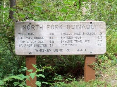
North Fork Quinault River
Hike along one of the major river valleys that winds deep into the heart of the Olympic wilderness until it joins with the Elwa River trail in the high alpine country at Low Divide. Walk among massive Sitka Spruce, giant Western Hemlocks and corridors of mossy maples that line the trail. This is the southern portion of the Press Expedition and the Bailey Range Traverse. There are some good peaks to scramble from Low Divide and along the Skyline Trail.
getting there
From US-101 38 miles north of Hoquiam, turn east onto South Shore Road. Drive 12.9 miles, turn left, cross the Quinault River Bridge, and them immediately turn right onto North Shore Road. Continue 3.5 miles to the road's end and trailhead (525 ft).
on the trail
Hike the North Fork Quinault River Trail as far out and back as you like for a day hike or backpacking trip. Hiking to Low Divide and back makes for a nice four-day backpacking trip. Consider making a loop backpacking trip using the Elip Creek and/or primitive Skyline Trails.
Peaks to Scramble
There are some good peaks to scramble fro near Low Divide and along the primitive Skyline Trail. Adding a couple peaks can add 1-2 days, 20 miles and lots more elevation gain to a trip up the North Fork Quinault River. Here's a list of options from Olympic Mountains: A Climber's Guide.
- Mount Barnes (5,987 ft)
- Mount Queets (6,476 ft)
- Mount Meany (6,695 ft)
- Mount Noyes (6,173 ft)
- Cougar Mountain (5,987 ft)
- Mount Seattle (6,246 ft)
- Mount Christie (6,177 ft)
- Kimta Peak (5,399 ft)
- Mount Zindorf (5,539 ft)
- Mount Lawson (5,401 ft)
Information for Leaders
Scheduling & Permits
This route allows multiple bookings. Please check scheduled trips listed below in the "Activities" tab to see if there is another group already booked on the same day. Leaders are expected to contact the leader(s) of existing trips to ensure there are no concerns or conflicts, according to The Mountaineers Outdoor Ethics Policy. Please review our Group Size & Multiple Bookings page for guidance.
- Suitable Activities: Backpacking, Day Hiking, Scrambling
- Seasons: June, July, August, September, October
- Weather: View weather forecast
- Difficulty: Moderate
- Length: 33.0 mi
- Elevation Gain: 1,800 ft
- Land Manager: Olympic National Park
- Parking Permit Required: National Park Entrance Fee
- Recommended Party Size: 12
- Maximum Party Size: 12
- Maximum Route/Place Capacity: 12
- Green Trails Mt Christie No. 166
- Custom Correct Quinault-Colonel Bob
- Trails Illustrated Olympic National Park
- USGS Bunch Lake
- USGS Mount Hoquiam
- USGS Mount Christie
- USGS Kimta Peak
This is a list of titles that represent the variations of trips you can take at this route/place. This includes side trips, extensions and peak combinations. Not seeing a title that fits your trip? Log in and send us updates, images, or resources.
- North Fork Quinault River & Skyline Trail Loop
- Skyline Trail
- North Fork Quinault River & Elip Creek Loop
- Low Divide, Mount Christie & Mount Meany
There are no resources for this route/place. Log in and send us updates, images, or resources.
