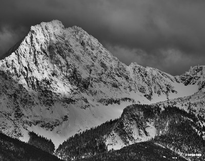
North Twin Sister/West Ridge
A fun 3rd class ridge scramble with some exposure, followed by a very steep glissade off the summit. Spectacular views of Mount Baker and Puget Sound. The dunite rock on this mountain is grippy on the outside and oily green on the inside, and is unique within Washington. Most parties use mountain bikes to reach the trailhead. Times: 6-7 hr trailhead to summit, 4-5 hr summit to trailhead.
getting there
Take I-5 to just north of Mount Vernon, then go east on SR-20 to Sedro Wooley. Go north on SR-9 to Acme. Turn right 0.3 miles from general store onto Mosquito Lake Road and drive 9 miles to steel bridge. Go another 0.75 miles to Forest Road 38. Turn right (south) on Forest Road 38 for approximately 5 miles. Stay right at the Y. Park at the gated bridge across the Nooksack even if the gate is open (1200 ft).
APPROACH
There are new logging roads in the area. The road is in good shape and easy to follow. Cross bridge and push your bike up the main logging road.
Note that you now want the FIFTH spur road on the right from the main logging road (previously the fourth). The first four right-hand spur roads are all passed in the first 1.5 miles. You will also pass at least two logging roads on the left (Forest Road 9030 and 9050).
After entering a large clear-cut are we found the turn-off (at 2600 ft) marked by a large cairn on a tree stump, the first of four such cairns marking road turns. This road is improved and in good shape. There is a steep road branching left (ignore) before a large bridge. Older reports state that there are boulders in this road and that it narrows at some point - the boulders are now gone and the road does not narrow.
After the bridge another turn-off is marked by another cairn (at approximately 3100 ft). This next road passes an old, overgrown road with a berm (Forest Road 9090 - ignore).
Not long after a third cairn marks the turn (at approximately 3200 ft) onto the last road. This last road is very overgrown and narrow but continue to push bikes up this road. It will switchback steeply before a final turn-off with a cairn at approximately 3900 ft. A hundred feet later the TH is reached at about 4000 ft. The climbers' trail is easily followed up to the ridge.
ASCENT ROUTE
Pass small scrub trees, keeping to right of ridge crest to top of prominent crag on crest (30 ft drop-off). False summit clearly visible from here, and obelisk tower just ahead. Move to about 100 ft right of crest and progress to about 800 ft from drop-off crag. Climb left on solid rock (class 3) to small headwall. Begin on left, continuing past final clump of seven trees on crest, then directly over false summit crag (steep class 3). Choose broken, exposed chimney or traverse right to ridge spur. Traverse around corner to rock and gully system. Climb steep rock with bucket holds (class 3), followed by scrambling summit (class 3 and 4). Many variations.
DESCENT ROUTE
In early season (May-June) descent can be made by glissading a long, steep snow field on the north slope of North Twin Sister, then traverse around to intersect the west ridge at 4,600 ft and join the trail. Later in the season, descend the climbing route.
TRIP PROFILE
| SEGMENT | TIME (HR) | ELEVATION GAIN (FT) |
|---|---|---|
| Seattle to Trailhead | 2 | |
| Trailhead to Summit | 6-7 | 5,300 |
| Summit to Trailhead | 4-5 |
EQUIPMENT
Light alpine gear and helmets. Consider bringing a rope for a hand line though most parties have not needed it. Ice ax may be needed before August. Mountain bike for the road.
NOTES
The rock on North Twin Sister makes for very pleasant climbing though be careful of loose rock. Most parties do not rope up for this climb although some portions are exposed. If you are on 5th class rock, you are not on-route. This is a long day trip!
Note that recent logging activity has resulted in better logging roads and more of them - older trip reports are now inaccurate. The approach description is updated. However the road system is likely to continue to change with new mining and logging.
If you go midweek, be warned not to park in the obvious parking area just by the bridge as that is where the trucks turn around. Rather, park down the road a little.
- Suitable Activities: Climbing
- Climbing Category: Basic Alpine
- Seasons: June, July, August, September, October
- Weather: View weather forecast
- Difficulty: Basic Alpine Climb, Strenuous 2, Technical 1, Basic Experience Climb
- Length: 16.0 mi
- Elevation Gain: 5,400 ft
- 6,570 ft
-
Land Manager:
Mount Baker-Snoqualmie National Forest
Mount Baker Ranger District (MBSNF)
- Parking Permit Required: Northwest Forest Pass
- Recommended Party Size: 12
- Maximum Party Size: 12
- Maximum Route/Place Capacity: 12
- USGS Twin Sisters Mountain
- USGS Cavanaugh Creek
There are no resources for this route/place. Log in and send us updates, images, or resources.
