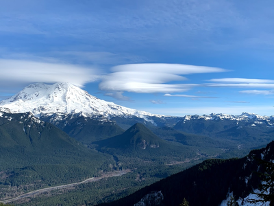
Osborne Mountain Trail
Located southwest of Mount Rainier, this a multi-use trail that leads to alpine lakes and peaks in the Sawtooth area. Enjoy view of Mount Rainier and the Nisqually River Valley. The trail is open to motorcycles, hikers, horses and bicycles.
getting there
Drive SR-706 to 2.5 east of Ashford, turn right onto Forest Road 52 (Kernahan Road), and drive 1.9 miles to the Big Creek Campground on the right (1,800 ft).
on the trail
Pothole, Bertha May & Granite Lakes
up to 13 miles round trip and 2,800 feet of elevation gain
From the Big Creek Campground, hike the Osborne Mountain Trail (No. 250) ascending steeply through the forest. In 2.6 miles (3,800 ft) stay left and hike through a timber harvest area to the south side of Osborne Mountain. The trail is passes a switchback in Forest Road 8410 at mile 4. Continuing southeast, the trail skirts a timber harvest area and leads to trail junction and with the Teeley Creek Trail (No. 251). Go left to reach Pothole Lake in ~0.3 mile or right to reach Lower Bertha May and Granite Lakes in 0.3 and 0.6 mile, respectively. Note that it is possible to make a loop trip by using mountain bikes or a car shuttle.
scramble route
osborne mountain (5,051 ft)
8 miles round trip, 3,400 feet of elevation gain
difficulty: Strenuous 3, Technical 2 or Winter scramble
Hike the Osborne Mountain Trail (No. 250) 2.6 miles, until reaching the three-way junction. Take a hard left on the trail and then immediately gain the northwest ridge to Osborne Mountain (5,051 ft). Eventually reach a logging road and follow it to just below the Osborne Mountain summit. There are some good views from the summit, but the best views are a little farther down the ridge to the east.
notes
- The Osborne Mountain Trail is open to motorcycles, hikers, horses and bicycles.
Information for Leaders
Scheduling & Permits
- If you are scheduling this as a non-course related activity, please limit your group size to the recommended party size. The maximum party size is for use by course field trips only, and includes both students and instructors. Group size maximums do not reflect how course field trips are run (in smaller groups of students and instructors), but allow for course leaders to register the course in our system.
- Suitable Activities: Day Hiking, Scrambling
- Seasons: Year-round
- Weather: View weather forecast
- Difficulty: Strenuous, Strenuous 3, Technical 2, Winter Scramble
- Length: 7.0 mi
- Elevation Gain: 3,400 ft
- 5,051 ft
-
Land Manager:
Gifford Pinchot National Forest
Cowlitz Valley Ranger District (GPNF)
- Parking Permit Required: Northwest Forest Pass
- Recommended Party Size: 12
- Maximum Party Size: 12
- Maximum Route/Place Capacity: 12
- Green Trails Randle No. 301
- USGS Sawtooth Ridge
This is a list of titles that represent the variations of trips you can take at this route/place. This includes side trips, extensions and peak combinations. Not seeing a title that fits your trip? Log in and send us updates, images, or resources.
- Osborne Mountain
- Osborne Mountain & Point 4856
- Pothole, Bertha May & Granite Lakes
There are no resources for this route/place. Log in and send us updates, images, or resources.
