Pacific Crest Trail: Chinook Pass to Norse Peak
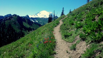
A Pacific Crest Trail ridge-walk extravaganza with fields of flowers and views of Mount Rainier. There are many moderate to very strenuous loop backpacking options up to 20 miles with 10 one-way miles on the PCT. Destinations along this section are Sheep Lake, Sourdough Gap, Bear Gap, Crown Point, Pickhandle Gap, Bullion Basin, Scout Pass, Norse Peak and Basin Lake.
getting there
From Enumclaw, drive east on SR 410 for about 50 miles to Chinook Pass and continue about 0.2 miles past Tipsoo Lake to the Pacific Crest Trail parking lot, the second large parking lot on the left side of the road.
From Naches, drive west on SR 12 to the junction with SR 410, turn onto SR 410 and drive about 45 miles to the Pacific Crest Trail parking lot on the right (if you get to Tipsoo Lake you've gone too far).
From Packwood, drive east on SR 12 to the junction with SR 123, and go north on SR 123 for ~16 miles to the junction with SR 410. Turn right onto SR 410 and continue about 0.2 miles to Pacific Crest Trail trailhead parking lot on the right just past Tipsoo Lake.
- The parking lot and trailhead are at ~5,440 ft.
ON THE TRAIL
The first mile of trail traverses a steep slope above Highway 410, with lovely wildflowers in the summer and berries in the fall. The trail then turns north-northeast and climbs gently on good trail passing through forest and small meadows for 1.1 miles more to Sheep Lake at (5,760 ft) in a beautiful little bowl. Past Sheep Lake the trail climbs steeply east and then north to Sourdough Gap at (6,380 ft) and 3.5 miles from the trailhead. This makes a lovely turnaround point for a day hike, or overnight based at Sheep Lake.
Just beyond Sourdough Gap is the junction with the Crystal Lakes Trail that heads down for about a mile to the lake and then 2.7 miles further down to Highway 410. This would make a nice loop day hike or overnight backpack with a shuttle car left at the Crystal Lakes Trailhead. (Crystal Peak also makes a wonderful view-filled side trip from this trail.)
After Sourdough Gap the trail crosses a short way across a steep scree slope that can be slow to melt out and has a long runout - check trip reports before trying to cross without an ice axe. For miles beyond this point it is a fabulous ridge ramble where flowers continue to emerge in bright splendor and views are wide and dramatic. Two miles from Sourdough Gap is Bear Gap (5,912 ft) and a junction with the Crystal Mountain Trail heading west for 3.3 miles to the ski area. Shortly thereafter, a junction with the unmaintained Fog City Trail that is to the right. At approx 1.3 miles past the Crystal Mountain trail junction, the Pacific Crest Trail (PCT) that turns sharply west and the Union Creek Trail that heads downhill and north. This trail is a "short cut" to Basin Lake but is severely damaged (as of 216) and not recommended. For Basin Lake stay on the PCT. Continue west on the PCT, which then curves sharply north around Crown Point (6,483 ft). If you have time, scramble up this grassy knob for fabulous views of Mount Rainier. About 1.3 miles beyond Crown Point, the Bullion Basin trail cuts off to the west, making another loop option in 2 miles from the Crystal Mountain ski area parking lot.
Continue on the PCT from the Bullion Basin Trail junction, walk about 2 miles crossing back and forth across a high ridge with meadow country on both sides to a fork at Scout Pass (6,500 ft). Norse Peak (6,710 ft) is just ahead. Find the climber's trail to the peak off the right fork. To the right are various trails heading down to Basin Lake about 3/4 mile below in a bowl under some high and colorful cliffs often frequented by goats!. Basin Lake has lakeside meadow camping options. Return to Chinook Pass the way you came or create a loop via one of the side trails.
PCT Miles
- Chinook Pass to Sheep Lake: 2.1 miles
- Sheep Lake to Sourdough Gap and Crystal Lake Trail junction: 1 mile
- Sourdough Gap to Bear Gap and Crystal Mountain Trail junction: 2 miles
- Crystal Mountain Trail junction to Bullion Basin Trail junction: 2.7 miles
- Bullion Basin Trail junction to Scout Pass: 1.8 miles (Scout Pass to Norse Peak ism 0.2 miles)
FOr leaders
Permit information
As of 2017, the Snoqualmie Ranger District considers Mountaineers trips and courses to be "nominal use". Leaders should print and copy this designation letter to show rangers they may see on trail or carry a digital copy on their phone.
- Suitable Activities: Backpacking
- Seasons: July, August, September, October
- Weather: View weather forecast
- View avalanche forecast.
- Difficulty: Strenuous, Moderate, Very Strenuous
- Length: 20.0 mi
- Elevation Gain: 4,000 ft
- 6,710 ft
-
Land Manager:
Mount Baker-Snoqualmie National Forest
Snoqualmie Ranger District (MBSNF)
- Parking Permit Required: Northwest Forest Pass
- Recommended Party Size: 12
- Maximum Party Size: 12
- Maximum Route/Place Capacity: 12
- Green Trails Lester No. 239
- Green Trails Bumping Lake No. 271
- Green Trails Mt Rainier East No. 270
- Green Trails Mount Rainier Wonderland No. 269SX
This is a list of titles that represent the variations of trips you can take at this route/place. This includes side trips, extensions and peak combinations. Not seeing a title that fits your trip? Log in and send us updates, images, or resources.
- Pacific Crest Trail: Chinook Pass to Crown Point
There are no resources for this route/place. Log in and send us updates, images, or resources.
