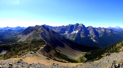
Pacific Crest Trail: Harts Pass to Manning Park
Backpack north to Holman Pass and loop back along Pasayten Creek, the Seven Passes Loop, or walk all the way to Manning Park in Canada on Section L of the Pacific Crest Trail, rambling high ridges with immense and impressive views. Destinations include Slate Peak, Windy Pass, Oregon Basin, Holman Pass, Hopkins Pass, Hopkins Lakes and Castle Pass.
getting there
From Mazama (on SR 20), turn left on Harts Pass Road (Forest Road 5400) and drive about 20 miles to its end at Harts Pass. This road is very rough, winding and narrow in places, and can be quite harrowing in the dark or in bad weather.
on The Trail
This stunning section of the Pacific Crest Trail (PCT) starts at nearly 6,200 ft and doesn't drop below 5,000 ft until you reach Canada! Meadows and immense views abound, but water sources can be far apart and snow can linger making it treacherous to cross some north slopes before mid-August.
From Harts Pass, the trail climbs north to a campground at 1.2 miles and reaches a junction at 1.4 miles with a spur to Forest Road 5400. For a nice side trip, walk about a mile from the junction on the forest road to Slate Peak Lookout.
Continue straight on the PCT for another 2.9 miles to 6,550 ft Buffalo Pass and 0.9 miles more to 6,257 ft Windy Pass. At Windy Pass you’ll enter the Pasayten Wilderness, a good turnaround point for a day hike from Harts Pass, 10.4 miles round trip.
For the next 2.2 miles, traverse around the northeast flanks of Tamarack Peak (watch for larch!) to Foggy Pass (6,180 ft) and another 0.7 miles to Jim Pass (6,270 ft), above lovely Oregon Basin. The trail then traverses a steep side slope around Devil's Backbone under the craggy mass of Jim Peak (7,033 ft), across the headwaters of Shaw Creek, and then down on steep switchbacks to Holman Pass (5,050 ft), 5.7 miles beyond Jim Pass and 13.8 miles from Harts Pass. Along the way enjoy views of the North Cascades, Mount Baker, Glacier Peak and the surrounding Pasayten Wilderness.
Continuing north from Holman pass, climb steadily past a spring and nice campsite at 2.4 miles (the first reliable water since Hart's Pass). Above here, on a steep climber's trail, are the tiny Goat Lakes and (reportedly!) a few small camps with water. Beyond the spring, climb the west flank of Holman Peak past another spring to Rock Pass (6,800 ft), 3.2 miles from Holman Pass. About 1.5 miles beyond Rock Pass, descend a north facing scree slope that can be treacherous well into summer, and reach a junction with Rock Creek Trail, No. 473, another access opportunity to the Pasayten River far below.
Continuing on the PCT 0.5 miles beyond the junction, cross 6,624-foot Woody Pass (which isn't at all woody!), and 3.2 miles beyond, reach the high point of this entire section at 7,216 ft, an unnamed summit on Lakeview Ridge. A spur trail to Hopkins Lake and campsites is reached at 4.9 miles beyond Woody Pass, and Hopkins Pass (6,122 ft) is just beyond that spur down a very steep set of switchbacks known as the Devil's Stairway. From Hopkins Pass it's a 2.5 mile nearly straight shot traversing the west slope of Mountt Winthrop to Castle Pass (5,451 ft), 27 miles from Harts Pass.
At Castle Pass, you'll cross the Boundary Trail which heads east across the wilds of the Pasayten to Iron Gate, and west on the Three Fools trail to Ross Lake. Continuing north from Castle Pass, it's 4.1 miles and 1,210 feet down to the Canadian border at Monument 78. If you want to cross here you will need a permit (find a link to the permit application on the PCTA website). From Monument 78 it is another 8.1 miles to Manning Park Lodge. From here it is possible to catch a bus (one time a day, 11am as of May 2016) to Vancouver, and from there, a bus or train back to Seattle.
seven passes loop
At Holman Pass, you can turn right on a 2 mile connector trail that leads to the West Fork Pasayten Trail. Turn right (south) on it and hike 8.5 miles back to Slate Peak and the Hart’s Pass parking lot. This is know as the "Seven Passes Loop" in the out-of-print Best Loop Hikes Washingtonby Dan Nelson (The Mountaineers Books, 2002). It really is seven passes--Harts, Buffalo, Windy, Foggy, Jim, Holman, and Slate. It's a 27-mile loop with 2,000 feet of elevation gain.
PCT miles
- Harts Pass to Windy Pass: 5.2 miles
- Windy Pass to Holman Pass: 8.6 miles
- Holman Pass to Rock Pass: 3.2 miles
- Rock Pass to Hopkins Pass: 5.1 miles
- Hopkins Pass to Castle Pass: 2.5 miles
- Castle Pass to Monument 78 (Canadian Border): 4.1 miles
- Monument 78 to Manning Lodge: 8.1 miles
- Suitable Activities: Backpacking
- Seasons: Year-round, July, August, September, October
- Weather: View weather forecast
- View avalanche forecast.
- Difficulty: Moderate, Strenuous, Very Strenuous
-
Land Manager:
Okanogan-Wenatchee National Forests
Pasayten Wilderness
- Parking Permit Required: Northwest Forest Pass
- Recommended Party Size: 12
- Maximum Party Size: 12
- Maximum Route/Place Capacity: 12
- Green Trails Washington Pass No. 50
- Green Trails Pasayten Peak No. 18
- Green Trails Jack Mountain No. 17
- Trails Illustrated North Cascades National Park
This is a list of titles that represent the variations of trips you can take at this route/place. This includes side trips, extensions and peak combinations. Not seeing a title that fits your trip? Log in and send us updates, images, or resources.
- Seven Passes Loop
There are no resources for this route/place. Log in and send us updates, images, or resources.
