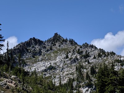
Paddy-Go-Easy Peaks
Hike to Paddy-G-Easy Pass and continue on and scramble one or more of the peaks from the pass. Sherpani is the unofficial name of the 6,520-foot peak three summits north of the pass. Tucquala Peak is to the south. Enjoy good views of the central Cascades peaks.
getting there
Take Exit 80 off of I-90 (Roslyn/Salmon la Sac) and drive north on Bullfrog Road. Turn left onto SR-903, drive through Roslyn, and then 16 miles to Salmon la Sac. Take the right fork onto Forest Road 4330 (Cle Elum Valley Road) and drive 9.5 miles. Cross the vehicle ford across Scatter Creek, drive on the Fish Creek Ranger Station and then continue past it to the Paddy-Go-Easy Trailhead on the right (3,400 ft).
approach & ascent
Sherpani Peak (6,520 ft)
10.0 miles round trip, 3,800 feet of elevation gain, difficulty: strenuous 4, technical 4
Hike the Paddy-Go-Easy Trail until it makes its turn into the draw leading to the pass (~5,700 ft). Leave the trail and make a level northwesterly traverse, staying on forested slopes below talus fields. Turn right into the drainage heading to the 6,120 ft pass southeast of Point 6564. A miner’s track leads to tailings and a caved-in mine entrance below the pass. From the pass traverse the basin to the southeast of Point 6564, cross its east ridge, then traverse the next basin to attain the pass between Point 6564 and Sherpani Peak. Reach Sherpani Peak's east ridge by a sloping shelf and follow it to the summit rocks. Circle the summit block counterclockwise and approach the summit from the northeast through a large keyhole. There is one final more difficult move to get on top of the summit block. There is a tradition of calling the peak Coffin Peak because of its characteristic rock at the summit.
Tucquala Peak (6,821 ft)
7.0 miles round trip, 3,400 feet of elevation gain, difficulty: strenuous 3, technical 3
- Suitable Activities: Scrambling
- Seasons: March, April, May, June, July, August, September, October, November
- Weather: View weather forecast
- Difficulty: Strenuous 4, Technical 4, Strenuous 3, Technical 3
- Length: 8.0 mi
- Elevation Gain: 3,800 ft
- 6,564 ft
- Land Manager: Okanogan-Wenatchee National Forests
- Parking Permit Required: Northwest Forest Pass
- Recommended Party Size: 12
- Maximum Party Size: 12
- Maximum Route/Place Capacity: 12
- Green Trails Stevens Pass No. 176
- USGS The Cradle
This is a list of titles that represent the variations of trips you can take at this route/place. This includes side trips, extensions and peak combinations. Not seeing a title that fits your trip? Log in and send us updates, images, or resources.
- Paddy-Go-Easy North Peak
- Sherpani Peak
- Paddy-Go-Easy South Peak
- Tucquala Peak
There are no resources for this route/place. Log in and send us updates, images, or resources.
