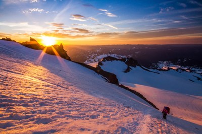
Mount Rainier/Fuhrer Finger
A Grade II climb featuring glacier travel on 30°-45° snow and ice slopes. Climb Fuhrer Finger or Fuhrer Thumb, a narrow couloir to the west of the finger.
getting there
From SR-7 in Elbe, turn east onto SR-706, both known as the National Park Highway. Continue through the Nisqually Entrance of Mount Rainier National Park. Be prepared to pay the fee just after entering the park. Drive 19 miles to Paradise.
In winter, ALL drivers in the park are required to carry snow chains or equivalent traction devices—this includes those with a 4-wheel or all-wheel drive vehicle. Those without a 4-wheel or all-wheel drive vehicle may be required to install them at Longmire or beyond.
APPROACH
Hike to the Nisqually Moraine Trail and descend to the Nisqually Glacier. Cross the Nisqually at approximately 6,200 ft and ascend Wilson Gully on the opposite (west) side of the glacier. Beware of rockfall potential in Wilson Gully. Follow Wilson glacier along the left edge to about 9,000 ft, then cut across to the right towards the cleaver between Wilson and Nisqually glaciers. There is a good campsite at 9,500 ft. Some parties have made camp at 10,000 ft but had to dig platforms.
ASCENT ROUTE
Fuhrer Finger
Climb directly up the finger toward the junction with the upper Nisqually Glacier. Watch for rockfall. Continue up the slopes to the top of Wapowety Cleaver at 13,000 ft, staying left near the cleaver. Climb levels out here, but you may have to negotiate crevasses.
Fuhrer Thumb
Head toward the finger, and climb the narrow couloir between the Wilson Glacier Headwall and Fuhrer Finger to 11,500 ft. Climb out of the couloir onto Fuhrer Finger to avoid the cliffs at the top of the couloir. Continue to the summit following the remainder of the Fuhrer route.
WILSON HEADWALL
From the campsites at ~9,500 ft, climb the northwest end of the Wilson Glacier to the series of moderate-angle (30°-50°) snow ramps separated by rock bands located climber's left of the Fuhrer's Thumb. Access might be limited by a bergschrund. The headwall continues for 3,000 feet and terminates at the top of the Wapovety Cleaver, ~13,000 ft. Rock bands lower down can be crossed by snow fingers on the sides. Exposure to ice fall from the Kautz Ice Cliff requires early start and moving fast on the route.
DESCENT ROUTE
Descend the climbing route or carryover and descend the Disappointment Cleaver route.
TRIP PROFILE
| SEGMENT | TIME (HR) | ELEVATION GAIN (FT) |
|---|---|---|
| Seattle to Trailhead | 2.5 | |
| Trailhead to Camp | 6 | 4,100 |
| Camp to Summit | 5-7 | 4,900 |
| Summit to Trailhead | 6-8 |
EQUIPMENT
Standard glacier gear, pickets, and/or flukes.
NOTES
- As one of the shortest routes on Rainier, a very fast party can climb it in one day from Paradise.
- Under good snow conditions, this route offers good moderate-angles snow climbing.
INFORMATION FOR LEADERS
PERMITS
A climbing permit is required for trips on glaciers and/or above 10,000 ft. Fees apply. Check with Mount Rainier National Park (land manger link below) to be sure you have the required camping and climbing permits.
- Suitable Activities: Climbing
- Climbing Category: Intermediate Alpine
- Seasons: May, June, July
- Weather: View weather forecast
- Difficulty: Intermediate Mountaineering Climb
- Elevation Gain: 10,000 ft
- 14,411 ft
-
Land Manager:
Mount Rainier National Park
Mount Rainier Wilderness
- Parking Permit Required: National Park Entrance Fee
- Recommended Party Size: 12
- Maximum Party Size: 12
- Maximum Route/Place Capacity: 12
- Green Trails Mount Rainier Wonderland No. 269SX
- Green Trails Mt Rainier East No. 270
- Green Trails Mt Rainier West No. 269
- USGS Mt Rainier East
- USGS Mt Rainier West
This is a list of titles that represent the variations of trips you can take at this route/place. This includes side trips, extensions and peak combinations. Not seeing a title that fits your trip? Log in and send us updates, images, or resources.
- Mount Rainier/Fuhrer Thumb
- Mount Rainier/Wilson Headwall
There are no resources for this route/place. Log in and send us updates, images, or resources.
