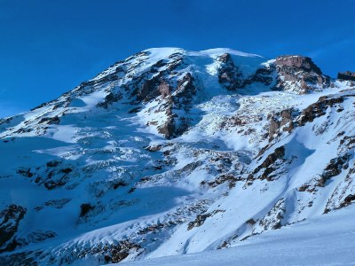
Mount Rainier/Gibraltar Ledges
Often called "Gib Ledges," this route on Mount Rainier is Grade II with 35-50° snow and ice.
getting there
From SR-7 in Elbe, turn east onto SR-706, both known as the National Park Highway. Continue through the Nisqually Entrance of Mount Rainier National Park. Be prepared to pay the fee just after entering the park. Drive 19 miles to Paradise.
In winter, ALL drivers in the park are required to carry snow chains or equivalent traction devices—this includes those with a 4-wheel or all-wheel drive vehicle. Those without a 4-wheel or all-wheel drive vehicle may be required to install them at Longmire or beyond.
APPROACH
From Paradise, hike the Skyline Trail to Panorama Point. Continue up, crossing Pebble Creek, then up the Muir Snowfield to Camp Muir, 10,050 ft.
ASCENT ROUTE
Ascend western edge of the Cowlitz Glacier below the Cowlitz Cleaver. Pass beneath the Beehive and cross the cleaver through a notch to reach the base of Gibraltar Rock. Follow obvious ledge system, placing pickets as necessary to protect from exposure. Ascend ice chute, crux, between Gibraltar Rock and upper Nisqually ice cliff to the saddle between Gibraltar Rock and the final summit slopes. Continue for a long 2,000 ft to the east crater rim. Cross crater to true summit.
DESCENT ROUTE
Descend via the climbing route. Alternatively, during periods of high rockfall, one could descend the Ingraham Glacier and then pass through Cadaver Gap of Cathedral Rocks to return to camp.
TRIP PROFILE
| SEGMENT | TIME (HR) | ELEVATION GAIN (FT) |
|---|---|---|
| Trailhead to Camp | 6 | 4,680 |
| Camp to Summit | 7 | 4,330 |
| Summit to Camp | 5 |
EQUIPMENT
Standard glacier gear, flukes and pickets.
NOTES
- This climb can only be recommended during winter months due to extreme rockfall and icefall on the ledges. Beware of rockfall and icefall during mid-day warming.
- This is a direct and straightforward route.
INFORMATION FOR LEADERS
PERMITS
A climbing permit is required for trips on glaciers and/or above 10,000 ft. Fees apply. Check with Mount Rainier National Park (land manger link below) to be sure you have the required camping and climbing permits.
- Suitable Activities: Climbing
- Climbing Category: Intermediate Alpine
- Seasons: January, February, December
- Weather: View weather forecast
- View avalanche forecast.
- Difficulty: Intermediate Mountaineering Climb
- Elevation Gain: 9,010 ft
- 14,411 ft
-
Land Manager:
Mount Rainier National Park
Mount Rainier Wilderness
- Parking Permit Required: National Park Entrance Fee
- Recommended Party Size: 12
- Maximum Party Size: 12
- Maximum Route/Place Capacity: 12
- Green Trails Mt Rainier West No. 269
- USGS Mt Rainier West
- USGS Mt Rainier East
- Green Trails Mt Rainier East No. 270
There are no resources for this route/place. Log in and send us updates, images, or resources.
