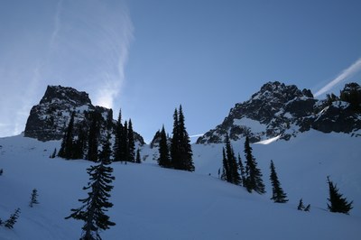
Pinnacle Peak & The Castle (Winter)
From the Narada Falls Trailhead, Castle-Pinnacle Saddle is a strenuous, 6-mile snowshoe or ski trip with 1,400 feet of elevation gain in the Tatoosh Range of Mount Rainier National Park. The route leads up past Reflection Lake and goes through a wide open bowl to the saddle between the two peaks. For climbers it's on to a winter ascent of Pinnacle Peak or The Castle.
getting there
From the Nisqually Entrance of Mount Rainier National Park, drive the plowed road past Longmire to the Narada Falls parking lot which is kept plowed each winter.
In winter, ALL drivers in the park are required to carry snow chains or equivalent traction devices—this includes those with a 4-wheel or all-wheel drive vehicle. Those without a 4-wheel or all-wheel drive vehicle may be required to install them at Longmire or beyond.
approach & ascent
castle-pinnacle saddle (6,100 ft)
Snowshoe up to gain the road to Reflection Lakes and traverse on it to the base of Pinnacle Peak. Ascend the ridge directly north of Pinnacle Peak before dodging left (east) into the basin between Pinnacle and The Castle. Gain the Pinnacle-Castle saddle. Skiers enjoy some yo-yo skiing in the basin before returning to your cars. It's 6 miles rounf trip and 1,400 feet of elevation gain.
pinnacle peak/south route (6,562 ft)
From the Narada Falls parking lot, follow the Paradise Road to Reflection Lake. Find the Pinnacle trailhead, and ascend to the Pinnacle-Plummer saddle. Watch for avalanche conditions while passing under the west face of Pinnacle. From the saddle, turn east and ascend steep snow slopes to the ascent gully. From the top of the gully, ascend through trees to the summit. Depending on conditions, one or two roped pitches gain the summit. Descend by rappelling the gully. Bring pickets for the snow slopes and maybe one or two small cams for the gully. An ice tool can be helpful. Crampons and snowshoes or skis may be required. It's 6.0 miles round trip and 2,200 feet of elevation gain.
the castle/East Ridge (6,440 ft)
ski route
See the "Resources" tab below for a map, elevation profile, and trip segments for the best ski route.
- Suitable Activities: Backcountry Skiing, Climbing, Snowshoeing
- Snowshoeing Category: Intermediate
- Seasons: January, February, March, April, December
- Weather: View weather forecast
- View avalanche forecast.
- Difficulty: Moderate, M1 Intremediate Ski
- Length: 6.0 mi
- Elevation Gain: 1,400 ft
- 6,100 ft
-
Land Manager:
Mount Rainier National Park
Mount Rainier Wilderness
- Parking Permit Required: National Park Entrance Fee
- Recommended Party Size: 12
- Maximum Party Size: 12
- Maximum Route/Place Capacity: 12
- USGS Mt Rainier East
- Green Trails Mt Rainier East No. 270
- Green Trails Mount Rainier Wonderland No. 269SX
This is a list of titles that represent the variations of trips you can take at this route/place. This includes side trips, extensions and peak combinations. Not seeing a title that fits your trip? Log in and send us updates, images, or resources.
- Castle-Pinnacle Saddle
- Pinnacle Peak/South Route
- The Castle/East Ridge
| Name/Description |
|---|
| Topo Map A topo map of the winter route to Castle-Pinnacle Saddle by Darryl Olson created in CalTopo Feb 2020. |
| Elevation Profile A elevation profile for the winter route to Castle-Pinnacle Saddle by Darryl Olson Feb 2020. |
| Trip Segments An Excel spreadsheet of trip segments with direction, distance, etc. for the winter route to Castle Pinnacle Saddle by Darryl Olson Feb 2020. |
