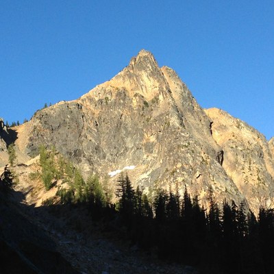
Poster Peak/Blue Buttress
Poster Peak is an unlabeled high point on the ridge running southeast from the Liberty Bell group. The Blue Buttress route ascends the left of the two northeast buttresses. It is a long climb but of moderate technical difficulty and has a short approach; it can be easily climbed in a single day.
Getting there
Drive SR-20 to the hairpin turn one mile east of Washington Pass and park in the large turnout.
APPROACH
Follow the trail up the valley towards Kangaroo Pass. Before the trail makes its steep rise to the pass leave the trail and angle up towards Poster Peak. Traverse under and to the left of the two northeast buttresses. Head up around the toe of the left buttress about 200 feet to a short upward-sloping ramp that gains the crest.
ASCENT ROUTE
In general, follow the broad ridge to the summit. There are many route options along the way and much of it can be scrambled or simul-climbed. It is around a dozen pitches if fully belayed out, depending on the length of your pitches. The technical sections are short, with ratings up to 5.6.
DESCENT
Continue past the summit and scramble down and to the left towards the saddle. Turn left and descend the northeast-facing bowl over very loose scree (or snow in the early season) to the start of the climb.
TRIP PROFILE
| SEGMENT | TIME (HOURS) | ELEVATION GAIN (FEET) |
|---|---|---|
| Trailhead to Climb | 2 | 1,400 |
| Climb to Summit | 5 | 1,000 |
| Summit to Trailhead | 2 |
EQUIPMENT
Light rack to three inches.
NOTES
- The summit is slightly ESE of the point marked 7565 on the USGS Washington Pass map.
- A useful reference with a detailed climbing topo is Washington Pass Climbing by Ian Nicholson (SuperTopo, 2012).
- In the Cascade Alpine Guide Vol 3, 3rd ed., Beckey calls this peak "Pica Peak" under the discussion of Copper Point but most other sources use the name Poster Peak.
- Suitable Activities: Climbing
- Climbing Category: Intermediate Alpine
- Seasons: May, June, July, August, September, October
- Weather: View weather forecast
- Difficulty: Intermediate Rock Climb
- Length: 3.0 mi
- Elevation Gain: 2,425 ft
- 7,565 ft
-
Land Manager:
Okanogan-Wenatchee National Forests
Methow Valley Ranger District (OWNF)
- Parking Permit Required: None
- Recommended Party Size: 12
- Maximum Party Size: 12
- Maximum Route/Place Capacity: 12
- USGS Washington Pass
- Green Trails North Cascades Ross Lake No. 16SX
There are no resources for this route/place. Log in and send us updates, images, or resources.
