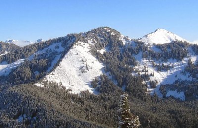
Pratt Lake Trail
Pratt Mountain is a early season snow scramble or a winter scramble, Pratt Lake is a strenuous day hike, and Pratt Vista is strenuous snowshoe trip near Snoqualmie Pass. The trail goes through scenic forests and meadows past Pratt Mountain to a secluded lake. Talapus, Olallie, Rainbow, Island, and Lower Tuscohatchie Lake are other lakes that are accessible from the Pratt Lake Trail.
getting there
summer
Take Exit 47 off of I-90, turn north and then west (left) onto Forest Road 9035, and continue 0.4 mile to the Pratt Lake Trailhead (1,900 ft).
winter
Take Exit 47 off of I-90 and turn north and then west (left) onto Forest Road 9035. If the road is plowed continue on to the Pratt Lake Trailhead. If not, park on the frontage road near the freeway interchange. Avoid parking in the interchange to prevent having your car towed.
on the trail
Pratt Lake
11 miles round trip with 2,300 feet of elevation gain
Take the Pratt Lake Trail to a junction at 4,200 ft and take the right fork to continue on to Pratt Lake.
Pratt Mountain
11 miles round trip with and 3,200 feet of elevation gain
Take the Pratt lake Trail to a junction at 4,200 ft. Take the left fork onto the Mount Defiance trail. When the trails begins to cross a boulder field (~0.5 mi), ascend the boulder field right (north) to the summit.
Kaleetan Lake
22 miles round trip, 5,100 feet of elevation gain
Take the Pratt Lake Trail to a junction at 4,200 ft and take the right fork to continue on to Pratt Lake. Continue 0.6 mile past Pratt Lake, turn left onto the Kaleetan Lake Trail, and hike 3.9 miles to Kaleetan Lake, passing Windy Lake in 3.1 miles. The trail past Windy Lake is difficult to follow.
Approach & Ascent
In April and May, Pratt Mountain may be done as a snow scramble. From December to March it is a winter scramble.
Follow the Pratt Lake Trail until the intersection with the Olallie Lake Trail. Turn onto this trail, or simply go cross-country to cross the outlet stream from Olallie Lake. Talapus Lake Trail joins it just after the crossing. Shortly before the lake, head steeply uphill towards the saddle to the east of the southeast trending ridge of Pratt Mountain. Follow the ridge to the summit at the north end.
Snowshoe Routes
Ollalie Lake
4 miles round trip with 1,200 feet of elevation gain, 3,780 ft high point, Difficulty: Basic Snowshoe
From the trailhead, follow the route of the summer trail—it is easy to follow until at 3,500 ft. At 3,800 ft and SSE of Ollalie Lake, follow the route of the summer trail as it heads north around Ollalie Lake.
Pratt Vista
11 miles round trip with 2,300 feet of elevation gain, 4,100 ft high point, Difficulty: Intermediate Snowshoe
Pratt Vista is the ridge due north of Olallie Lake between West Granite and Pratt Mountains. At ~4,000 ft and northeast of Ollalie lake, the summer trail bends to the left. Leave the trail here and ascend north to the ridge. If avalanche conditions are “considerable” or higher, keep to the left to stay more in the trees, otherwise, keep right to have more open terrain. Upon reaching the ridge, enjoy the view of Pratt to the west, Kaleetan to the north, and Tusk O’ Granite to the east. Follow the ridge west then southwest to just past the lowest spot on the ridge at 4,150 ft. Turn southeast and descend the forested slopes to the outlet of Ollalie Lake and then retrace your route to the trailhead.
Information for leaders
Permit information
As of 2017, the Snoqualmie Ranger District considers Mountaineers trips and courses to be "nominal use". Leaders should print and copy this designation letter to show rangers they may see on trail or carry a digital copy on their phone.
- Suitable Activities: Backpacking, Day Hiking, Scrambling, Snowshoeing, Trail Running
- Seasons: April, May, June, July, August, September, October
- Weather: View weather forecast
- View avalanche forecast.
- Difficulty: Technical 3, Strenuous 3, Strenuous, Winter Scramble
- Length: 11.0 mi
- Elevation Gain: 3,200 ft
- 5,099 ft
-
Land Manager:
Mount Baker-Snoqualmie National Forest
Alpine Lakes Wilderness, Snoqualmie Ranger District (MBSNF)
- Parking Permit Required: Northwest Forest Pass
- Recommended Party Size: 12
- Maximum Party Size: 12
- Maximum Route/Place Capacity: 12
- Green Trails Snoqualmie Pass Gateway No. 207S
- USGS Bandera
- USGS Snoqualmie Pass
This is a list of titles that represent the variations of trips you can take at this route/place. This includes side trips, extensions and peak combinations. Not seeing a title that fits your trip? Log in and send us updates, images, or resources.
- Pratt Lake
- Pratt Mountain
- Pratt Vista
- Olallie Lake
- Talapus Lake
- Talapus & Olallie Lakes
- Rainbow & Island Lakes
- Lower Tuscohatchie Lake
- Kaleetan Lake
