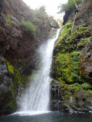
Quicksilver Creek
A beautiful south-facing canyon that boasts jumps, slides, scenery, and technical rigging. This Basic Canyon typically flows at v3a3III during the second half of the summer.
GETTING THERE
Take Exit 70 off of I-90 and drive west on Sparks Road (it's on the north side of and parallel to the interstate). In 0.7 mile turn right onto Kachess Dam Road and follow it first north, and then northeast for about a mile. Turn right onto the gravel Forest Road 4818. Drive ~1 mile and turn right and continue ~0.5 mile to the Kachess Ridge Trailhead (2,400 ft).
APPROACH
Hike the Kachess Ridge Trail for 30-45 minutes, depending on the speed of your group. The trail is a steady steep grade, and gets quite a bit of sun exposure so plan to have water available. The trail eventually begins to parallel the creek, and at this point, there is a trail down to the drop-in. There is plenty of space on the rocks at the drop-in for a party of 6-8 to put on wet suits.
DESCENT
Quicksilver has six drops in total, two of which are jumps, and four rappels. Be sure to send someone to the pools to check depth before jumping!
- Jump 1: 8 feet (3 m) into a pool right at the start of the canyon. This can easily be downclimbed DCR (Down Canyon Right).
- Rappel 1: 40 feet (12 m) on bolts DCR. This can be rigged with a short rope that ends half way, as the drop turns into a slide. Canyoners can rappel off the end of the rope to enjoy the slide. Traverse line bolts are available about 15 feet back, but are only needed for high water access.
- After Rappel 1, enjoy a relatively easy creek walk through a sunny open canyon. There is a downclimb with two large boulders that is easy to navigate with passing bags and spotter support. Continue downstream a few minutes more to the top of Rappel 2 on your left.
- Rappel 2: 60 feet (20 m) on bolts DCL (Down Canyon Left). Traverse line bolts are placed about 35 feet back above the small pothole DCL. Use a retrievable traverse line.
- Rappel 3: 40 feet (12m) from a tree DCL. This begins a three-tiered technical sequence. Beware of loose rocks at the top of the first rappel. The canyoner rappels off the tree, and rigs a rebelay at the visible anchors at the edge of the pool, DCR.
- Rebelay: exit is into a calm pool, but climbing up to the hand line anchors on the other side of the pool may be slippery. Consider leaving enough rope to protect this, as the next waterfall follows immediately.
- Hand line: Anchors DCR for a 15-foot traverse line. This is best rigged retrievable.
- Rappel 3a: 70 feet (25 m) bolts DCR accessed via hand line. This rappel is out of the flow until the last 5', but ends in a deep pool in dispersed flow. Setting rope length is very helpful here.
- Jump 2: 12 feet (3 m). In 2020, this was a large pool about 10-12 feet deep.
- Rappel 4: 30 feet (9 m) from a webbing anchor in a rock pinch DCL. Staying DCL on rappel will keep you from swinging into the large pothole DCR.
EXIT
After the final rappel, scramble downstream for about 20 minutes, until the pine forest transitions into hardwoods. There is a steep hillside on the right that prevents a safe exit. Scramble downstream until that hillside tapers out, shortly after the transition to hardwoods. The exit trail is not obvious, but look for branches that have been sawed off to help clear the beginning. Traverse the hillside, generally up and left (staying left earlier leads away from the scree to a pleasant meadow), until reconnecting with the Kachess Ridge Trail. Follow the trail down back to the trailhead.
EQUIPMENT
Standard canyoning gear including a wrench and replacement quick links. This canyon can be very windy in the narrows, and the water is unexpectedly cold. Even on a hot day, plenty of neoprene is needed.
TRIP PROFILE
- Rappels: 4-6
- Longest Rappel: 70 feet
- Approach: ~ 1 mile
- Exit: ~0.75 mile
- Time: 5-7 hours total
NOTES
- This canyon is rated v3a3III at moderate-low water levels, and v3a4III in early to mid-season.
- For more information and recent trip reports from the community, visit the Quicksilver listing at ropewiki.
- Suitable Activities: Canyoning
- Seasons: July, August, September
- Weather: View weather forecast
- Difficulty: Basic Canyon
- Length: 2.0 mi
- Elevation Gain: 1,500 ft
-
Land Manager:
Okanogan-Wenatchee National Forests
Cle Elum Ranger District (OWNF)
- Parking Permit Required: None
- Recommended Party Size: 6
- Maximum Party Size: 8
- Maximum Route/Place Capacity: 8
- Green Trails Alpine Lakes East (Stuart Range) No. 208SX
- Green Trails Kachess Lake No. 208
- USGS Kachess Lake
This is a list of titles that represent the variations of trips you can take at this route/place. This includes side trips, extensions and peak combinations. Not seeing a title that fits your trip? Log in and send us updates, images, or resources.
- Silver Creek
There are no resources for this route/place. Log in and send us updates, images, or resources.
