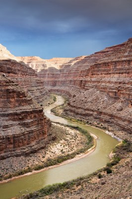
San Juan River
Packraft up to 83 miles of the the Class II-III San Juan River in Bears Ears National Monument, southeast Utah. The scenic red-rock canyon of the “River Flowing From Sunrise” is rich with archaeology, geologic features, hiking opportunities, and wildlife.
FLOW
- USGS Gauge: San Juan River near Bluff, UT
- NOAA Advanced Hydrologic Prediction Service: San Juan River near Bluff, UT
- Navajo Dam in New Mexico controls flows on the San Juan River and there is usually adequate flow for boating all year.
- American Whitewater’s recommended flow range is 500 – 8,000 cfs.
Put-ins & Take-outs
The San Juan River can be boated for 26.9 miles from Sand Island to Mexican Hat or 83.4 miles on from Mexican Hat to Clay Hills Crossing. Mileage, below, is determined relative to the Sand Island put-in, consistent with the “Guide to the San Juan River” by Whitis and Martin.
Sand Island put-in
The BLM maintains a boat ramp, campground, and ranger station at Launch site at the Sand Island Recreation Area (Mile 0), 4 miles ESE along Hwy 191 from Bluff, UT and about 0.5 mile upstream of the Hwy 191 bridge. The campground has vault toilets, a trash dumpster, and drinking water.
Clay Hills take-out
The unimproved Clay Hills Boat Ramp is at Mile 83.4. It may be necessary at low water to carry boats across a mudflat to access the ramp. Clay Hills is the only viable road-accessed take-out below Mexican Hat.
Mexican Hat, alternate put-in or take-out for a shorter trip
To run the 26.9 miles from Sand Hills to Mexican Hat, or the 56.5 miles from Mexican Hat to Sand Hills, take-out or put-in at the BLM boat ramp, at Mile 26.9 at the town of Mexican Hat. Access is off HWY 163 on the south side of Valle’s Trailer Park. There are bathrooms and trash dumpsters.
ON THE RIVER
While the San Juan River has a number of Class II drops and one Class III drop, it is more notable for its spectacular red rock canyon scenery, many hiking opportunities, abundant archaeology and history, geographic and geologic features, and large population of bighorn sheep and other wildlife
Campsites along the river are first-come except for all campsites downstream of Government Rapids (Mile 64), which must be reserved in advance. Any camping or hiking on river left requires a permit from the Navajo Nation.
Sand Island to Mexican Hat (26.9 miles)
Eight Foot Rapid (Mile 17.2) is the most technical of several Class II rapids in this section. This section has some of the greatest petroglyph panels in the Southwest and has some large Puebloan ruins. Hiking opportunities include a trail to Mule’s Ear Diatreme, a volcanic pipe formed by magma from the upper mantle, and to a perched meander (Mile 12.7).
Mexican Hat to Clay Hills (56.5 miles)
This reach has several Class II rapids and one Class III rapid, Government Rapid (Mile 63.7). At about Mile 67, the river passes through the Goosenecks, a classic example of an entrenched meander. Habitat for desert bighorn sheep is abundant. This section has a number of side canyons to explore, including Slickhorn Canyon, Grand Gulch, and Oljeto Wash, and trails leading to views on the canyon rim, notably Honaker Trail.
LOGISTICS
Permits
- Permits are issued by the BLM online through recreation.gov. Permits for launch dates April 15 – July 15 are by lottery and for other launch dates may be reserved in advance.
- Land on river left is within the Navajo Nation. Camping or hiking on Navajo Nation land requires a hiking and camping permit from the Navajo Parks and Recreation Dept.
- Campsites downstream of Government Rapids (Mile 64) must be reserved in advance through recreation.gov.
Guides, Maps & Online Resources
- “Guide to the San Juan River, Montezuma Creek to Clay Hills Crossing, Utah,” Fourth Edition (Duwain Whitis and Tom Martin, 2023) has river maps and detailed information on the route and background on the region.
- The BLM provides a downloadable, georeferenced map of the San Juan River.
- American Whitewater describes the runs on San Juan 01. Sand Island to Mexican Hat (Upper San Juan) and San Juan 02. Mexican Hat to Clay Hills Crossing (Lower San Juan).
Car Shuttles
- Round trip driving time for the Sand Island to Clay Hills shuttle is 4-5 hours. Round trip driving time for the Sand Island to Mexican Hat shuttle is less than 1 hour. Commercial shuttle services are available.
Water
All drinking water should be carried. Filtering water is difficult because the river water is very silty and tributary channels are unreliable. The river may also contain agricultural chemicals.
Human Waste
Human waste must be carried out in a “leak-proof, animal-proof, hard-sided container with a screw-on or ratchet-locking lid.”
Other requirements include carrying one spare paddle for every three boats and a metal fire pan at least 12” in diameter.
- Suitable Activities: Packrafting
- Seasons: Year-round
- Weather: View weather forecast
- Difficulty: Class II River, Class III River
- Length: 83.4 mi
- Land Manager: Utah BLM
- Parking Permit Required: BLM Permits & Passes
- Recommended Party Size: 12
- Maximum Party Size: 12
- Maximum Route/Place Capacity: 12
There are no resources for this route/place. Log in and send us updates, images, or resources.
