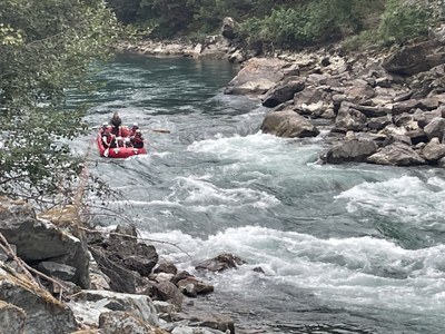
Skagit River: Goodell Creek to Copper Creek
This section of the river is a great place for advanced packrafting beginners to learn from an experienced paddler. Dam release allows for consistent flows along a beautiful river.
FLOW
- NOAA Gauge: SKAGIT--CASCADE RIVER AT MARBLEMOUNT (CSCW1)
- Flow Range: 1,500 - 15,000 cfs is runnable, but over 6,000 cfs the main rapid can become III+ and big eddy lines can develop. Seattle Light controls the flow just upriver a the hydroelectric plant making this runnable in the lean summer months when most other area rivers are too low.
- Gradient: 14 fpm
PUT-IN
- Goodell Creek Campground at Mile 119.4 on SR-20. There is a boat launch and information sign at the downstream end of the campground. Be sure to leave room for rafters to access the launch by parking cars outside the campground on the dirt road.
TAKE-OUT
- River Mile 84.1, Copper Creek: Drive SR-20 to Mile 111.7 where NPS Road 213, a dirt road, heads south to the river and just before the Ross Lake Recreation Area sign. Follow the NPS Road 213 ~200 yards, then take the left fork to the takeout. Parking options are limited here. If you have a large group, park extra vehicles at the put-in. This makes for an 8.5 mile float.
- River Mile 78.2, Marblemount: In Marblemount at SR-20 Mile 106, the road makes a hard 90° bend. Instead of following the highway, continue straight across the bridge over the Skagit River. In ¼ mile the public access parking lot and boat launch is on the right. From the river the take-out is on river left just downstream of the bridge. This makes for a 15 mile float.
ON THE RIVER
The run starts with easy Class II rapids. It's a good section for practice with strong eddy lines and occasional wave trains. Next is about 5 miles of casual floating to the highlight of the run, the "Shovel Spur Rapids" or "S-Bends," a series of three distinct rapids separated by short stretches of flatwater. The big wave trains are normally rate Class III, but become bigger and faster with higher water levels (6,000+ cfs), no more difficult than Class III+.
It is possible to eddy out on river left before the S-Bends. The first of the three drops has a ledge that extends about one-third of the width of the river on river left which could eat a pack rafter. Line up with the tongue in the center or slightly right of center for the safest line. A big wave train cannot be avoided. If someone swims here they may be able to self rescue in the flow before the next drop if they hold onto their boat, but there are no eddies. The second drop of the three is where the river makes the S-turn, turning slightly right then sharp left. Start middle right and make a hard right to left move through the rapid to avoid the boulder embankment on river right. Swimming here means swimming the next drop—swim to the right if you can. The third and final drop has a big boulder and hole smack in the middle of the river. It is easily avoided by lining up on either side. The right side has more blue water and less waves. The S-Bends can be scouted from the road between Mile 114.1, upstream end and start of rapid, and Mile 113.5, downstream end.
The river calms down considerably after leaving the S-Bends and continues along at any easy pace the final two miles to the takeout.
Notes
- Learn more on American Whitewater's Skagit, Goodell Creek to Copper Creek web page.
- There is good cell phone coverage in Marblemount.
- Suitable Activities: Packrafting
- Seasons: Year-round
- Weather: View weather forecast
- Difficulty: Class III River
- Length: 8.5 mi
- Land Manager: Land Manager Varies
- Parking Permit Required: see "Put-Ins" & "Take-Outs" sections (above)
- Recommended Party Size: 12
- Maximum Party Size: 12
- Maximum Route/Place Capacity: 12
- Green Trails North Cascades Ross Lake No. 16SX
There are no resources for this route/place. Log in and send us updates, images, or resources.
