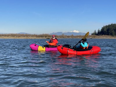
Skagit River: Rockport to La Conner
Paddle the Skagit river from Rockport in the North Cascades to the salt water of northern Puget Sound. There are many options for tips along this section of the river.
Flow
- NOAA Gauge: SKAGIT--NEAR CONCRETE (CONW1) and SKAGIT--NEAR MT VERNON (MVEW1)
Put-ins & Take-outs
- Howard Miller Steelhead Park, Rockport: A large park with ample parking, a boat launch, and toilets.
- Faber Ferry North Boat Launch: Also known as the John G Young Landing, this is aboat launch on the Skagit river. Drive east from Concrete on SR-20 ~5 miles, turn right at public fishing sign onto Faber Road, and drive the paved road to its end. There is parking for 10+ cars and toilets.
- Baker River, Concrete: From Concrete drive east on SR-20. After crossing the Baker River, find a dirt road and drive that to the confluence with the Skagit River. There is parking for ~6 cars, but no toilet.
- Hamilton Boat Launch: Drive east from Hamilton on SR-20 to Cape Horn Rd, at Milepost 78.5 turn right (south) onto Cape Horn Rd, drive 200 yards to Shangrila Dr. and continue 0.75 miles to parking on the left with toilets.
- Riverfront Park, Sedro-Woolley: Has a boat ramp and toilets.
- Edgewater Park, Mount Vernon: Has a boat ramp and toilets.
- Spudhouse Boat Launch: A Washington Department of Fish & Wildlife (WDFW) boat launch.
- Rexville DFW Access: A gravel parking area on the side of Moore Road with a short trail leading to the river and a protected eddy. From Rexville, drive south over Best Road bridge, take the first left onto Moore Road., continue 1/2 mile and park on the left where the road bends right. From the parking area, walk 500 feet west on the gated gravel and grass road and then take the use trail on the right to the river. If paddling directly to Conner Waterfront Park this makes for a 6.5 mile float, which may only take 2 hours. The advantage of this put-in is that it allows more time to explore the many side sloughs and islands, with options to paddle all day long.
- La Conner Waterfront Park and Boat Launch: At the south side of the Maple Ave Bridge.
These are the most commonly used put-ins and take-outs. Visit the WDFW access points map for more put-ins and take-outs along the river.
On the River
Rockport to Mt Vernon
57 miles
The Skagit River is a large, fast flowing river that passes through private and public lands.
Spudhouse to La Conner
10 miles
Paddle through the North Skagit river delta to salt water and to La Conner. What starts as a lazy river float through agricultural lands, changes dramatically to estuarine habitat, and then to the Sound where there are several islands to explore—Ika Island, Fidalgo Island, and Goat Island. On a clear day, dramatic views of Mount Baker can be seen on river right.
Time your trip to catch the ebbing tide. At the mouth of the North Skagit River find southern entrance to the Swinomish Channel to paddle to La Conner. This entrance can be difficult to locate because of a long rock jetty that runs from the mainland to Goat Island. In the middle of the jetty is a a cut, called Hole in the Wall, that allows passage. It is marked by a small orange pole and located at 47.3699, -122.5065. At high water this can be paddled and at lower water boats can be carried. Once through the Hole in The Wall, the entrance to the Swinomish Channel is located in a deep cut in the rock walls between McGlina and Fidalgo Islanda. The current can be very challenging if the tide is ebbing—plan for a flowing tide so that it is in your favor. There is a road on the right (river left) around the first bend to the boat chandlery. The take out is about 1 mile up the Swinomish Channel.
Worst case, Sullivan Slough, ~0.5 mile before Hole In The Wall, may be paddled north for ~0.5 mile to a side channel on the left (river right) to a take-out with a walk to the nearest road in town.
- Suitable Activities: Packrafting
- Seasons: Year-round
- Weather: View weather forecast
- Difficulty: Class I River
- Length: 67.0 mi
- 235 ft
- Land Manager: Land Manager Varies
- Parking Permit Required: see "Put-Ins" & "Take-Outs" sections (above)
- Recommended Party Size: 8
- Maximum Party Size: 12
- Maximum Route/Place Capacity: 12
This is a list of titles that represent the variations of trips you can take at this route/place. This includes side trips, extensions and peak combinations. Not seeing a title that fits your trip? Log in and send us updates, images, or resources.
- Skagit River: Spudhouse to La Conner
There are no resources for this route/place. Log in and send us updates, images, or resources.
