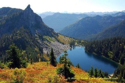
Mount McCausland
A strenuous 8-mile round trip snowshoe near Stevens Pass with 2,700 feet of elevation gain. It is very scenic and has great views.
getting there
Drive SR-2 to the Smithbrook Road turn off and parking area, 4.2 miles east of Stevens Pass. If coming from the east, drive Stevens Pass Nordic Center and use the U-turn access for SR-2 westbound to the parking area (3,200 ft). In summer, continue 2.8 miles on Smith Brook Road (Forest Road 6700) to the trailhead (3,950 ft).
Day hiking
7.0 miles round trip, 1,800 feet of elevation gain
snowshoe/scramble route
9.0 miles round trip, 2,800 feet of elevation gain
Travel up Smith Brook Road to the Smithbrook Trailhead (6,000 ft). Turn off the road and head cross-country, choosing a route to the saddle above Lake Valhalla.
ski route
See the "Resources" tab below for a map, elevation profile, and trip segments for the best ski routes.
notes
- Mount McCausland (not labeled on the USGS topo map) is the 5,747 ft peak located immediately north of Lake Valhalla.
- In winter, not permit is required. In summer a Northwest Forest Pass is required.
Information for LEADERS
scheduling
Many popular snowshoe and ski routes utilize Smith Brook Road parking area where this route begins. Review these other routes to be sure your trip will not conflict with others and encourage carpooling within your group.
- Suitable Activities: Backcountry Skiing, Day Hiking, Snowshoeing
- Snowshoeing Category: Intermediate
- Seasons: Year-round
- Weather: View weather forecast
- View avalanche forecast.
- Difficulty: Moderate/Strenuous, Moderate, M1 Intremediate Ski
- Length: 8.0 mi
- Elevation Gain: 2,700 ft
- 5,747 ft
-
Land Manager:
Okanogan-Wenatchee National Forests
Henry M Jackson Wilderness, Skykomish Ranger District (MBSNF)
- Parking Permit Required: Northwest Forest Pass
- Recommended Party Size: 12
- Maximum Party Size: 12
- Maximum Route/Place Capacity: 12
- Green Trails Alpine Lakes West (Stevens Pass) No. 176S
- Green Trails Benchmark Mtn No. 144
- USGS Labyrinth Mtn
| Name/Description |
|---|
| Mount McCausland Topo Map A topo map of the winter ascent and descent route to Mount McCausland by Darryl Olson created via CalTopo Feb 2020. |
| Dow Lake Elevation Profile An elevation profile of the descent route to Dow Lake from Mt McCausland by Darryl Olson Feb 2020. |
| North Bowl Evelation Profile An elevation profile of the descent route in the bowl on the north side of Mount McCausland by Darryl Olson Feb 2020. |
| North Ridge Elevation Profile An elevation profile of the descent route on the north ridge of Mount McCausland by Darryl Olson Feb 2020. |
| Mount McCausland Descent Profile An elevation profile of the descent route from Mount McCausland to the trailhead by Darryl Olson Feb 2020. |
| Ski Route Trip Segments An Excel spreadsheet of trip segments with direction, distance, etc. for the winter route to Mount McCausland by Darryl Olson Feb 2020. |
