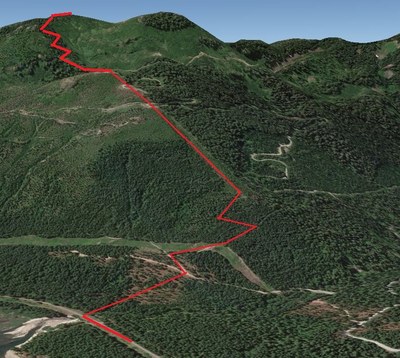
Roaring Ridge (Snoqualmie)
Ski the backcountry on northeast facing slopes near Hyak and Snoqualmie Pass.
getting there
Hyak Sno-Park
Take Exit 54 (Gold Creek/Hyak) off of of I-90 and turn south onto SR-906. At the intersection, turn left to stay on SR-906 and drive ~0.5 mile to the Hyak Sno-park (2,575 ft).
Hyak Parking Lot
Take Exit 54 (Gold Creek/Hyak) off of I-90 and turn south onto SR-906. At the intersection, continue straight and park at the Summit East (Hyak) Ski Area and Nordic Center parking lot (2,630 ft).
ski route
Newly thinned forest by the Roaring Thin project created some widely spaced forest on northeast facing slopes that appear worthy of investigation for new ski runs. The approach and exit involves approximately 2 miles of skiing the flat Palouse to Cascades State Park Trail (formerly John Wayne Trail)—bringing some kick-wax for this section is a good idea to avoid plodding on the flats with skins. After leaving the groomed trail, switch to skins and the usual backcountry ski setup.
- Suitable Activities: Backcountry Skiing
- Seasons: January, February, March, April
- Weather: View weather forecast
- View avalanche forecast.
- Difficulty: M1 Intremediate Ski
- Length: 8.0 mi
- Elevation Gain: 2,500 ft
- 5,000 ft
-
Land Manager:
Okanogan-Wenatchee National Forests
Cle Elum Ranger District (OWNF)
- Parking Permit Required: Discover Pass
- Recommended Party Size: 12
- Maximum Party Size: 12
- Maximum Route/Place Capacity: 12
- Green Trails Snoqualmie Pass Gateway No. 207S
- Green Trails Snoqualmie Pass No. 207
- USGS Snoqualmie Pass
This is a list of titles that represent the variations of trips you can take at this route/place. This includes side trips, extensions and peak combinations. Not seeing a title that fits your trip? Log in and send us updates, images, or resources.
- Roaring Ridge
