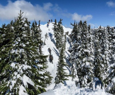
Sorcery Peak (winter)
Scramble to Point 5273 as it is labelled int he Green Trails and USGS maps and visit seldom-seen alpine lakes in the Alpine Lakes Wilderness. Do this in winter to avoid the brush after the snow melts.
getting there
Take Exit 34 off of I-90 and turn left onto 468 Ave SE. In a half mile, turn right onto SE Middle Fork Road (Forest Road 56). Drive 12.5 miles and turn right onto Forest Road 5620. Continue 5 miles to the Dingford Creek Trailhead (1,400 ft).
FOr leaders
Permit information
As of 2017, the Snoqualmie Ranger District considers Mountaineers trips and courses to be "nominal use". Leaders should print and copy this designation letter to show rangers they may see on trail or carry a digital copy on their phone.
- Suitable Activities: Scrambling
- Snowshoeing Category: Intermediate
- Seasons: January, February, March, December
- Weather: View weather forecast
- View avalanche forecast.
- Difficulty: Winter Scramble
- Length: 7.5 mi
- Elevation Gain: 3,800 ft
- 5,273 ft
-
Land Manager:
Mount Baker-Snoqualmie National Forest
Alpine Lakes Wilderness, Snoqualmie Ranger District (MBSNF)
- Parking Permit Required: Northwest Forest Pass
- Recommended Party Size: 12
- Maximum Party Size: 12
- Maximum Route/Place Capacity: 12
- Green Trails Skykomish No. 175
- Green Trails Mt Si No. 174
- USGS Snoqualmie Lake
- Green Trails Middle Fork Snoqualmie No. 174SX
- Green Trails Alpine Lakes West (Stevens Pass) No. 176S
This is a list of titles that represent the variations of trips you can take at this route/place. This includes side trips, extensions and peak combinations. Not seeing a title that fits your trip? Log in and send us updates, images, or resources.
- Sorcery Peak
- Point 5274
- Point 5274 (Sorcery Peak)
There are no resources for this route/place. Log in and send us updates, images, or resources.
