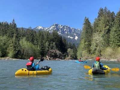
Stillaguamish River (South Fork): Deer Creek to Mallardy Creek
A continuous Class II+ river run with many fun rapids near the Mountain Loop Highway. It's a good alternative when the "Silly Stilly" run is too high.
Flow
- NOAA Gauge: SF Stillaguamish--Near Granite Falls (GFLW1)
- 6.0-7.5 feet: Class II+ River. At 6.5 feet, the river is technical and bony.
- This river is "flashy." Flow increases with rain and then subsides, making it unpredictable when the flow will be good for this section. When the next section downstream, from Boardman Creek is high, this section is usually in good flow, making it a good alternate.
PUT-IN
- Coal Creek Campground
- If the Mountain Loop Highway is closed, park west of the gate and put-in at the gate.
Take-Out
- Red Bridge Campground: At 7.5 miles, the river follows the road and then bends south around Red Bridge Campground. Land on a gravel beach just downstream from some logs placed along the shore.
- Boardman Creek: Continue to Boardman Creek, the put-in for the next section. At Boardman Creek, the main channel is on the north side of the river bed and there are several small channels between that and Boardman Creek.
ON THE RIVER
The Upper South Fork is continuous Class II+, an advanced Class II river run. There are frequent gravel bar and boulder drops with short pools in between. Most are fairly straight forward Class II boating while a few are more challenging. Wood is a common hazard on this stretch. Watch for small logs in some of the rapids and for river spanning trees. Because wood is more common, boaters should have good boat handling and river reading skills.
Notes
- Learn more on American White Water's Stillaguamish, S. Fork: 1 - Deer Creek to Mallardy Creek (Upper) web page.
- Because there is no cell phone coverage at Verlot, it is common to meet in Granite Falls.
- Suitable Activities: Packrafting
- Seasons: Year-round
- Weather: View weather forecast
- Difficulty: Class II+ River
- Length: 7.5 mi
- 1,630 ft
-
Land Manager:
Mount Baker-Snoqualmie National Forest
Darrington Ranger District (MBSNF)
- Parking Permit Required: Northwest Forest Pass
- Recommended Party Size: 12
- Maximum Party Size: 12
- Maximum Route/Place Capacity: 12
- Green Trails Mountain Loop Highway No. 111SX
There are no resources for this route/place. Log in and send us updates, images, or resources.
