Southeast Wallowas Loop
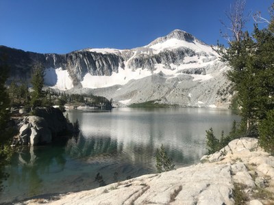
Visit more than 8 alpine lakes and high alpine terrain in Oregon’s spectacular Wallowa mountains and Eagle Cap Wilderness. This trip includes the beautiful Lakes Basin, but by a less-crowded southern route.
The Wallowa Mountains have almost 500 miles of trails, and every foot of every trail is worth taking. In all those magnificent miles, this loop may be the best. Here, before your awestruck eyes, the Wallowa Mountains present the perfect combination of sparkling lakes, clear streams, crashing waterfalls, deep canyons, high passes, wildflower meadows . .. it is almost impossible to take it all in. When asked to select my all-time favorite long hike in Oregon, this usually tops the list.
100 Classic Hikes in Oregon, 2nd ed.
Getting There
Drive southeast on OR-203 to Medical Springs, turn left onto Eagle Creek Dr. and drive 1.7 miles. Turn east, drive another 1.7 miles and turn left onto Forest Road 67. Drive 13 miles, just after crossing a bridge over Eagle Creek turn right, and drive 6 miles. Turn left onto Forest Road 7745, and drive 5.3 miles to the East Eagle Creek Trailhead (4,600 ft).
On the Trail
This very strenuous 46-mile loop trip includes more than 10,000 feet of elevation gain with the longest day of nearly 11 miles at elevations ranging from 4,600 ft to 9,600 ft.
Suggested Itinerary
Day 1: From East Eagle Trailhead, hike to Hidden Lake. It's 8.8 miles, 2,800 feet of elevation gain.
Day 2: Hike to Moccasin Lake, crossing Horton Pass, with an optional side trip up to Eagle Cap. It's 10.0 miles, 3,500 feet of elevation gain.
Day 3: Hike to Little Frazier Lake. It's 5.4 miles, 1,800 feet of elevation gain. Cross Glacier Pass and travel through the spectacular Glacier Lake Basin. Lorain rates Glacier Lake as the second most spectacular lake in Oregon, after only Crater Lake in Crater Lake National Park (not the Crater Lake visited the next day).
Day 4: Hike to Crater Lake. Cross Hawkins Pass, and ford the chilly calf-deep South Fork Imnaha River. It's 10.7 miles, 2,950’ gain.
Day 5: Return to the East Eagle Trailhead. It's 5.5 miles, 700 feet of elevation gain.
Notes
- In addition to our 100 Classic Hikes in Oregon, Backpacking Oregon: From Rugged Coastline to Mountain Meadow 2nd ed by Douglas Lorain (Wilderness Press 2007) is a good guidebook.
- Suitable Activities: Backpacking
- Seasons: July, August, September
- Weather: View weather forecast
- Difficulty: Strenuous/Very Strenuous
- Length: 46.0 mi
- Elevation Gain: 10,000 ft
- 9,600 ft
-
Land Manager:
Wallowa-Whitman National Forest
Eagle Cap Wilderness, Wallowa Valley Ranger District (WWNF)
- Parking Permit Required: Northwest Forest Pass
- Recommended Party Size: 12
- Maximum Party Size: 12
- Maximum Route/Place Capacity: 12
- Green Trails Wallowa Mountains No. 475SX
This is a list of titles that represent the variations of trips you can take at this route/place. This includes side trips, extensions and peak combinations. Not seeing a title that fits your trip? Log in and send us updates, images, or resources.
- Southeast Eagle Cap Wilderness Loop
| Name/Description |
|---|
| GPS Route Topo for Southeast Wallowas Loop A CalTopo route for the Southeast Wallowas Loop by Richard Lambe, March 2023. |
