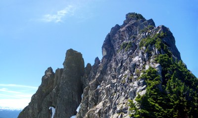
Spire Mountain
This is a very challenging scramble near Index with an all off-trail route of about 6 miles, 5,000 feet of elevation gain. The route goes directly up from the North Fork Skykomish River, finishing on the west ridge of the peak. A rope is sometimes used for short stretches of exposed climbing near the summit.
getting there
Drive US-2 to one mile easy of Skykomish and turn north onto Forest Road 65 (Beckler River Road). Just after crossing the North Fork Skykomish River, turn left onto Forest Road 63. In ~4.6 miles, Forest Road 63 crosses the river again and the road curves right and crests a small hill. Park here making sure not to block traffic on the road.
approach & ascent
This 6,213-foot summit is one of the least-often climbed of the Everett Pin Peaks. A cross-country route directly from the North Fork Skykomish River Valley reaches the north side of the peak. The final west ridge is mostly Class 3 with short stretches of Class 4 and 5 where a rope may be desired.
- Suitable Activities: Scrambling
- Seasons: June, July, August, September, October
- Weather: View weather forecast
- Difficulty: Strenuous 5, Technical 5
- Length: 6.0 mi
- Elevation Gain: 5,000 ft
- 6,213 ft
-
Land Manager:
Mount Baker-Snoqualmie National Forest
Sky Lakes Wilderness, Skykomish Ranger District (MBSNF)
- Parking Permit Required: None
- Recommended Party Size: 6
- Maximum Party Size: 6
- Maximum Route/Place Capacity: 6
- USGS Baring
- USGS Monte Cristo
- Green Trails Monte Cristo No. 143
This is a list of titles that represent the variations of trips you can take at this route/place. This includes side trips, extensions and peak combinations. Not seeing a title that fits your trip? Log in and send us updates, images, or resources.
- Spire Peak
There are no resources for this route/place. Log in and send us updates, images, or resources.
