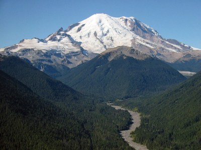
Goat Island Mountain
Goat Island Mountain is a moderate scramble with great views of the northeast side of Mount Rainier.
getting there
From SR-410 in Mount Rainier National Park, take Sunrise Road until it meets White River Road. Go straight on the White River Road towards the White River Campground. The trailhead parking area (3,900 ft) is located just past the bridge over Fryingpan Creek. There are no facilities at the trailhead.
ASCENT ROUTE
Hike the trail toward Summerland and after crossing bridge over Fryingpan Creek, leave trail (snow covered in early season) just before the switchbacks. Follow the right most creek, crossing as far up as possible and head for the saddle north of Point 6491. Alternatively, you can hike to the saddle past Point 6491. Then follow ridge to the summit.
For loop trip, return heading from the summit on a bearing of !110° and follow easiest contour.
- Suitable Activities: Scrambling
- Seasons: June, July, August, September
- Weather: View weather forecast
- Difficulty: Technical 3, Strenuous 3
- Length: 13.0 mi
- Elevation Gain: 3,500 ft
- 7,288 ft
-
Land Manager:
Mount Rainier National Park
Mount Rainier Wilderness
- Parking Permit Required: National Park Entrance Fee
- Recommended Party Size: 12
- Maximum Party Size: 12
- Maximum Route/Place Capacity: 12
- USGS White River Park
- Green Trails Mt Rainier East No. 270
- USGS Sunrise
There are no resources for this route/place. Log in and send us updates, images, or resources.
