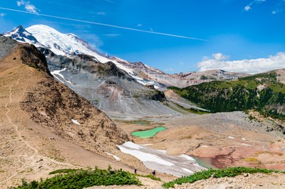
Summerland & Panhandle Gap
Hike through dark forest to flower-filled alpine meadows to Summerland and then on to Panhandle Gap on the Wonderland Trail in Mount Rainier National Park. Enjoy views of Goat Mountain, Fryingpan Glacier, Little Tahoma and Mount Rainier.
This hike is in Mount Rainier National Park. The National Park Service preserves unimpaired the natural and cultural resources and values of the National Park System for the enjoyment, education, and inspiration of this and future generations. The National Park Service cooperates with partners to extend the benefits of natural and cultural resource conservation and outdoor recreation throughout this country and the world.
All participants should orient themselves to the unique geologic hazards at Mt. Rainier, an active volcano.
getting there
From SR-410 in Mount Rainier National Park, take Sunrise Road until it meets White River Road. Go straight on the White River Road towards the White River Campground. The trailhead parking area (3,900 ft) is located just past the bridge over Fryingpan Creek. There are no facilities at the trailhead.
on the trail
summerland (5,900 ft)
8.5 miles round trip with 2,100 feet of elevation gain, Moderate
This is one of the most popular hikes and backpacks in Mount Rainier National Park and the parking lot at Fryingpan Creek fills early on summer weekends. Begin in a cool forest, break out into sun and cross a footbridge over Fryingpan Creek. Then climb through meadows with views up to Goat Mountain, turn a corner, and switchbacks up steeply for 800 flower-filled feet to break out into alpine meadows with spectacular views of Little Tahoma, Mount Rainier, Fryingpan Glacier, and Panhandle Gap. There is a stone shelter at 5,600 ft and five backcountry campsites, with views to the east of the Sarvent Glacier and Cowlitz chimneys. Fryingpan Creek bubbles through sunny meadows just below the shelter.
panhandle gap (6,800 ft)
12 miles round trip with 2,950 feet of elevation gain, strenuous
From Summerland, continue on 2 miles and 840 feet to Panhandle Gap.
Summerland & Indian Bar
15.5 miles one way with 4,600 feet of elevation gain
From Summerland continue on 2 miles and 840 feet to Panhandle Gap then keep going south on the Wonderland Trail through Indian Bar, exiting at either Box Canyon or Olallie Creek. This trip can be done as a long day hike or as a one- or two-night backpack with a car shuttle. See our Indian Bar-Cowlitz Divide route/place for trips going south-to-north from the Box Canyon Trailhead. Two groups, one hiking north-to-south and the other south-to-north, can do one-way trips with a key exchange.
notes
- This is a popular area and is the starting point for scrambling Meany Crest and Goat Island Mountain, and climbing Little Tahoma.
- Suitable Activities: Backpacking, Day Hiking
- Seasons: June, July, August, September, October
- Weather: View weather forecast
- Difficulty: Moderate
- Length: 8.5 mi
- Elevation Gain: 2,100 ft
- 5,900 ft
- Land Manager: Mount Rainier National Park
- Parking Permit Required: National Park Entrance Fee
- Recommended Party Size: 12
- Maximum Party Size: 12
- Maximum Route/Place Capacity: 12
- Green Trails Mt Rainier East No. 270
- Green Trails Mount Rainier Wonderland No. 269SX
This is a list of titles that represent the variations of trips you can take at this route/place. This includes side trips, extensions and peak combinations. Not seeing a title that fits your trip? Log in and send us updates, images, or resources.
- Summerland
- Panhandle Gap
- Summerland & Indian Bar
- Summerland, Panhandle Gap & Indian Bar
There are no resources for this route/place. Log in and send us updates, images, or resources.
