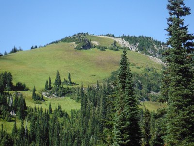
Tamanos Mountain, Governors Ridge, Barrier Peak & Buell Peak
Moderate to challenging scrambles in the northeast corner of Mount Rainier National Park from Owyhigh Lakes. Tamanos Mountain and the Barrier & Buelle combo are the most commonly done. If you're looking for more of a challenge, traverse to Banshee Peak through the Sarvant Glacier Valley. If you want a longer scramble with more peaks make a one-way trip that visits Tamanos Mountain, Governors Ridge, Barrier Peak, and Buell Peak.
getting there
Drive SR 410 4.5 miles south of the Crystal Mountain Ski Area turnoff and turn right on Sunrise Park Road. Drive 3.4 miles to the Owyhigh Lakes Trailhead (3,760 ft).
approach & ascent
tamanos mountain (6,790 ft)
11 miles round trip, 3,000 feet elevation gain
difficulty: Strenuous 3, Technical 2
Hike the Owyhigh trail ~200 yards past Owyhigh Lakes (3.6 miles) where the trail breaks out of the trees (~5,400 ft). Leave the trail and head northwest (290°) and gain the ridge at 6,260 ft. Follow the ridge to the summit (6,790 ft). On technical sections of rocky outcroppings, follow on the west side of the ridge.
Governors Ridge (6,614 ft) & Barrier Peak (6,521 ft)
11 miles round trip, 3,400 feet of elevation gain
difficulty: strenuous 3, technical 4
Hike to Owyhigh Lakes, ascend toward saddle north of Barrier. Drop over to the east side of the ridge, and descend and traverse north past three buttresses. Ascend 300 feet in the gully, then ascend and traverse north and scramble highest point on ridge (6,600 ft). Return to saddle and ascend south to summit of Barrier Peak. Descend the west ridge to the lowest saddle, then descend short gully and return to lakes.
tamanos-banshee traverse
17 miles one-way, 5 miles of cross-country travel, 5,000 feet elevation gain
difficulty: Strenuous 5, Technical 4
Start at the Owyhigh Lakes Trailhead just after leaving a car at the Fryingpan Creek trailhead for the end of the traverse. Ascend Tamanos by way of the valley and lakes on its northern aspect before traversing to reach the 6,000-foot col on its southern aspect. From this col traverse and descend to reach Wright Creek at ~5,500 ft, then ascend to the 7,000-foot col just east of Banshee by way of the stagnant Sarvant Glacier (no glacier travel gear needed). After ascending Banshee, descend to and follow the Wonderland Trail to reach Summerland and your cars at the Fryingpan Creek Trailhead. Most of the scrambling is Technical 3 or lower in difficulty, but a short section of chossy rock on the northern aspect of Tamanos approaches Technical 4.
Tamanos Mountain, Governors Ridge, Barrier Peak & Buell Peak
11 miles one-way, 3,800 feet of elevation gain
difficulty: strenuous 3, technical 4
- Hike to Owyhigh Lakes in ~3.5 miles. About 200 yards past the lakes, the terrain flattens and the trail breaks out into the open (5,380 ft). Leave the trail here and head northwest at a bearing of approximately 295°, ascedning 850 feet and attaining the ridge at 6,260 ft. Head north and then slightly northwest to the Tamanos Mountain summit, staying on the left (west) side of the rocky outcroppings. Return to the Owyhigh Lake Trail and head back towards lake for about 500 feet or head straight across trail into the cross country zone. Travel east towards Governors Ridge keeping the hill top at 6,200 ft on the right.
- Climb toward the saddle north of Barrier Peak and over to the east side of the ridge. Descend and traverse north past three prominent buttresses. After the third buttress, climb 300 feet in the gully. Then ascend and traverse north, picking best route until reaching the highest point on Governors Ridge (6,614 ft). Return to the saddle.
- Travel south picking the best way around the rocks until reaching the Barrier Peak's summit. Descend the south side of Barrier Peak.
- Traverse the ridge to the summit of Buell Peak. Return to the Barrier-Buell saddle, descend southwest to the Owyhigh Lakes Trail, and hike southeast the Owyhigh Lakes Trail to the Deer Creek Trailhead.
- Suitable Activities: Scrambling
- Seasons: July, August, September, October
- Weather: View weather forecast
- Difficulty: Strenuous 3, Technical 2
- Length: 11.0 mi
- Elevation Gain: 3,000 ft
- 6,790 ft
-
Land Manager:
Mount Rainier National Park
Mount Rainier Wilderness
- Parking Permit Required: National Park Entrance Fee
- Recommended Party Size: 12
- Maximum Party Size: 12
- Maximum Route/Place Capacity: 12
- Green Trails Mount Rainier Wonderland No. 269SX
- USGS White River Park
- USGS Chinook Pass
This is a list of titles that represent the variations of trips you can take at this route/place. This includes side trips, extensions and peak combinations. Not seeing a title that fits your trip? Log in and send us updates, images, or resources.
- Tamanos Mountain
- Governors Ridge & Barrier Peak
- Tamanos-Banshee Traverse
There are no resources for this route/place. Log in and send us updates, images, or resources.
