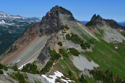
Tatoosh Range Traverse
Traverse the Tatoosh Range in Mount Rainier National Park. It's a scramble of 10 miles and 5,00 feet of elevation gain.
Getting There
From SR-7 in Elbe, turn east onto SR-706, both known as the National Park Highway. Continue through the Nisqually Entrance of Mount Rainier National Park. Be prepared to pay the fee just after entering the park. For here the starting and ending points can be Longmire, the Pinnacle Peak Trailhead, and the Bench Lake Trailhead.
Peaks in the Tatoosh Range
- Eagle Peak (5,598 ft)
- Chutla Peak (6,000 ft)
- Wahpenayo Peak (6,231 ft)
- Lane Peak (6,012 ft)
- Denman Peak (6,006 ft)
- Plummer Peak (6,370 ft)
- Pinnacle Peak (6,562 ft)
- The Castle (6,440 ft)
- Foss Peak (6,524 ft)
- Unicorn Peak (6,971 ft)
- Boundary Peak (6,760 ft)
- Stevens Peak (6,560 ft)
- Suitable Activities: Scrambling
- Weather: View weather forecast
- Difficulty: Strenuous 5, Technical 5
- Length: 10.0 mi
- Elevation Gain: 5,000 ft
- 6,562 ft
-
Land Manager:
Mount Rainier National Park
Mount Rainier Wilderness
- Parking Permit Required: National Park Entrance Fee
- Recommended Party Size: 12
- Maximum Party Size: 12
- Maximum Route/Place Capacity: 12
- USGS Randle
- USGS Mt Rainier East
- USGS Packwood
- USGS Mt Rainier West
- Green Trails Mount Rainier Wonderland No. 269SX
| Name/Description |
|---|
| Mountaineers Beta & Brews: Basic Climbs 2021 A link to the YouTube video of The Mountaineers Beta & Brews: Basic Climbs 2021. The Tatoosh Mini-Traverse (Unicorn, Foss, Castle, Pinnacle) presentation by Paul Brown and Ben Chapman begins at ~26:20. |
