Thornton Creek
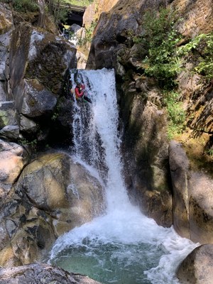
A steep creek in North Cascades National Park near Newhalem that features a fun triple slide at the top and 10-15 rappels up to 200 feet each. Many rappels are directly in the flow and several require crossing pools while on rappel, making this a technically challenging canyon.
Getting There
Drive SR-20 to 11 miles east of Marblemount and turn north onto Thornton Lakes Road. If running the entire canyon, leave a car at the bottom of Thornton Lakes Road near SR-20. Continue driving up the road to a bridge that crosses Thornton Creek. If running the canyon to this point and not continuing downstream, leave a car at the bridge. Continue up Thornton Lakes Road to the final switchback before the road straightens out. Park here and follow the trail up to the drop-in.
Approach
Follow a faint use trail uphill, paralleling the creek, to 1,200 ft and drop into the creek. For a shorter day, drop in at 1,130 ft, which shortens the descent by four rappels.
Descent
This canyon has multiple multi-stage rappels, some off of natural anchors and others off of bolted anchors. Many rappels require traversing potholes on rope, or end in a pothole that must be traversed to access the next rappel anchor. Be aware that in high flows, these potholes may contain hydraulics or risk pushing canyoneers over the pour-over. Only experienced teams should descend this canyon in conditions that exceed moderate—review the "waterflow" indicators on ropewiki.com.
Exit
Exit at the bridge, or follow the creek below the final rappel until it passes under Highway 20. Follow a path on the north side of Highway 20 back to your car.
EQUIPMENT
Standard canyoning gear including webbing, a wrench and replacement quick links.
TRIP PROFILE
- Rappels: 10-15
- Longest Rappel: 200 feet
- Approach: 0.25 mile
- Exit: 0.1 mile
- Time: 5-8 hours total
NOTES
- This canyon is rated v4a4III at moderate water levels (late August & September), and v4a5 in early to mid-season.
- It is possible to run upper sections of the creek, which are largely jumps and slides, but route has not yet been documented.
- For more information and recent trip reports from the community, visit the Thornton Creek listing at ropewiki.
- Suitable Activities: Canyoning
- Seasons: July, August, September
- Weather: View weather forecast
- Difficulty: Intermediate Canyon
- Length: 0.5 mi
-
Land Manager:
North Cascades National Park
Ross Lake National Recreation Area
- Parking Permit Required: None
- Recommended Party Size: 8
- Maximum Party Size: 12
- Maximum Route/Place Capacity: 12
- Green Trails North Cascades Ross Lake No. 16SX
There are no resources for this route/place. Log in and send us updates, images, or resources.
