Tieton River Nature Trail
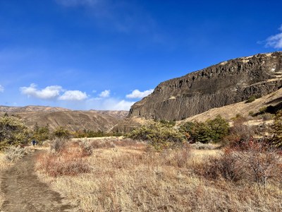
Hike an easy, relatively flat 7 miles along the Tieton River that follows Highway 12 in the Oak Creek Wildlife Area. The trail includes a couple of scenic bridges which allow for different access points along the highway. As this gentle trail winds along the river enjoy views of dramatic rock formations as well as abundant spring wildflowers and striking fall colors.
Getting There
From the west: Drive east on US-12 through Packwood to White Pass. Drive 36 miles and turn left into the Oak Creek Wildlife Recreation Area's large parking lot.
From the east: Drive west on US-12 4.4 past the stoplight in Naches to the junction with SR-410 (which leads to Chinook Pass). Turn left to stay on US-12, drive 2.0 miles, and turn right into the Oak Creek Wildlife Recreation Area's parking lot.
There are two other access points that connect the Nature Trail with US-12. One is via a suspension bridge across the river at the Quonset hut 1.3 miles west of the Visitor Center, and the other is via a footbridge at the west end of a large pullout 3 miles west of the Visitor Center.
On the Trail
Cross the highway and then the bridge across the Tieton River and turn right through a gate in the fence onto the Tieton River Nature Trail. Hike the trail along the river as far as desired. There's a suspension bridge at mile 1.3, a foot bridge at mile 3, and Forest Road 512 at mile 6.5. The trail begins to climb a bit just before and continues to climb after the foot bridge, but the views a mile or so past the footbridge are worth the effort.
Notes
- This trail is noteworthy for striking rock formations, abundant wildflowers in spring, and autumn's gorgeous fall colors.
- In summer as temperatures can be very hot. Be sure to stay well hydrated.
- Rattlesnakes and ticks call this area home.
- Suitable Activities: Day Hiking, Naturalist
- Seasons: March, April, May, June, September, October, November
- Weather: View weather forecast
- Difficulty: Easy/Moderate
- Length: 7.0 mi
- Elevation Gain: 764 ft
- 2,076 ft
- Land Manager: Oak Creek Wildlife Area
- Parking Permit Required: Discover Pass
- Recommended Party Size: 12
- Maximum Party Size: 12
- Maximum Route/Place Capacity: 12
- Green Trails Tieton No. 305
There are no resources for this route/place. Log in and send us updates, images, or resources.
