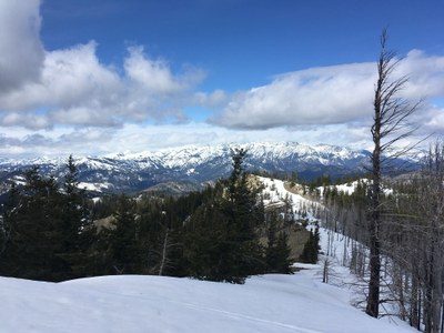
Tronsen Ridge
Tronsen Ridge runs north from Blewett Pass to the east of Route 97. It offers several options for winter scrambling when snow blocks many mountain access roads and the weather on the west slopes of the Cascades is unfavorable. The area offers a generally open understory, moderate slopes and good views. An 5-8 mi round trip open ridge walk with 1,000 ft elevation gain. Views to Mission Ridge, the Stuart Range, Mt. Rainier and Mt. Baker. An excellent wildflower walk with flowers appearing with snowmelt. Motorcycles allowed after mid-June.
Getting There
Northern Trailhead: Access from Five Mile Road (Forest Road 7224) off of SR-97 ~6 miles north of Blewett Pass. This road is rutted and steep, and requires a high clearance vehicle.
Southern Trailhead: From SR-97 just north of Blewett Pass, turn south onto Forest Road 9716. In 3.7 miles, turn left onto Forest Road 9712. Drive 5 miels to the KLen Wiclcox Horse Camp in Haney Meadow and then 1 mile further to the trailhead.
Winter: Park at the spur road heading east from SR-97 about 500 yards north of Tronsen Campground.
on the trail
The entire ridge is 7 mi. From north to south, the ridge gains 1,600 ft and lose 200 ft. Hike from the north or the south as far as desired enjoying the views and wildflowers.
notes
- Look for Tweedy's Lewisia and Lyall's Mariposa Lilyalong with 55 other varieties of wildflowers.
- Enjoy views of Mission Ridge, the Stuart Range, Mount Rainier and Mount Baker on clear days.
- The entire ridge may be done as a key exchange or with a car shuttle.
- Motorcycles allowed after mid-June.
Winter Routes
Approach from the ridge curling around to the northwest from Point 5575. The highest summit is 5,920 ft just east of the the "s" of "Wenatchee Mountains" on the Blewett Pass USGS map. There are views of the Stuart Range. Other spur ridges to Tronsen ridge can be combined for loop trips encompassing Points 4870, and, on USGS Tiptop map, 4970, 4536 or 4368.
- Suitable Activities: Day Hiking, Scrambling, Snowshoeing
- Seasons: Year-round
- Weather: View weather forecast
- View avalanche forecast.
- Difficulty: Easy/Moderate, Winter Scramble
- Length: 6.5 mi
- Elevation Gain: 1,000 ft
- 5,920 ft
-
Land Manager:
Okanogan-Wenatchee National Forests
Wenatchee River Ranger District (OWNF)
- Parking Permit Required: Northwest Forest Pass
- Recommended Party Size: 12
- Maximum Party Size: 12
- Maximum Route/Place Capacity: 12
- Green Trails Wenatchee No. 211S
- Green Trails Liberty No. 210
There are no resources for this route/place. Log in and send us updates, images, or resources.
