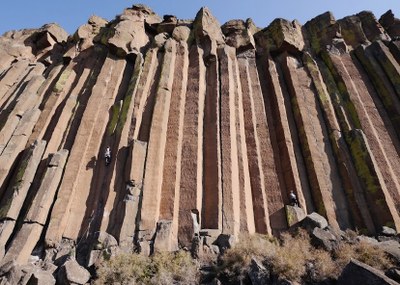
Trout Creek Climbing Area
A rock climbing crag in eastern Oregon north of Smith Rock State Park. The climbing is physical, the rock is rough, and the approach is not bad. Climb vertical cracks in corners and stem-boxes on large basalt columns rated 5.10 to 5.12 with an increasing number of high quality 5.13s. There are also a handful of lower angle crack climbs on the north side of the crag rated 5.7 to 5.11.
getting there
From Madras, Oregon, drive US-97 north past Safeway and out of town. Turn left onto NE Cora Drive. It becomes NE Clark Drive which leads into Gateway, Oregon. Cross the train tracks, turn right and follow the signs to the Trout Creek Recreational Area.
approach
From the day-use area at the up-stream end of the Trout Creek Campground, follow the road/trail up stream for about 10 minutes. There are currently two trails up to the crag. One leaves the river right after the road jogs around a small berm (right after you pass a bench on your right) and switchbacks up to The Northern End. To get to the other, older trail, follow the road past the first trail for another 5 minutes, cross a small cattle guard, and look for a trail heading up and left during a long straightaway.
Crag Areas
- The Cool Wall
- The Main Wall
- The Northern End
notes
- Download a rough map of the crag areas.
- The Trout Creek trailhead also has a campground. There is a fee for camping.
- The Trout Creek Climbing Area is closed annually from Jan 15 to Aug 31 to protect nesting golden eagles. During the closure, visitors to the area may use the Trout Creek Campground and hike along the trail that follows the Lower Deschutes River to the south, but leaving the trail and heading uphill toward the climbing area is prohibited.
- The BLM website has a note: BLM staff will open all or part of the climbing wall by May 15th, when the eagles have selected their nest for the year, or a nest attempt has failed.
- Suitable Activities: Climbing
- Climbing Category: Rock Climb
- Seasons: January, February, March, April, September, October, November, December
- Weather: View weather forecast
- Difficulty: Crag Rock Climb
- Length: 4.0 mi
- Land Manager: Oregon-Washington BLM
- Parking Permit Required: BLM Permits & Passes
- Recommended Party Size: 12
- Maximum Party Size: 40
- Maximum Route/Place Capacity: 12
- USGS Trout Creek Butte, OR
- see Land Manager
This is a list of titles that represent the variations of trips you can take at this route/place. This includes side trips, extensions and peak combinations. Not seeing a title that fits your trip? Log in and send us updates, images, or resources.
- Trout Creek Crag
There are no resources for this route/place. Log in and send us updates, images, or resources.
