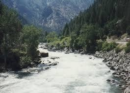
Tumwater Pipeline Trail
Trail along a river good for day hiking, exploring nature and photography.
getting there
Drive US-2 to 2 miles west of Leavenworth and turn south into the parking area (1,300 ft).
on the trail
This 1.2-mile trail follows the old pipeline that was abandoned by the railroad when it switched to diesel. It starts at the site of the power plant where parts of the foundation still remain. One of the most popular feature of the trail is the old iron bridge spanning the river.
- Suitable Activities: Day Hiking
- Seasons: April, May, June, July, August, September, October, November
- Weather: View weather forecast
- Difficulty: Easy
- Length: 2.4 mi
- Elevation Gain: 100 ft
- 1,400 ft
-
Land Manager:
Okanogan-Wenatchee National Forests
Cle Elum Ranger District (OWNF)
- Parking Permit Required: Northwest Forest Pass
- Recommended Party Size: 12
- Maximum Party Size: 12
- Maximum Route/Place Capacity: 12
- Green Trails Alpine Lakes East (Stuart Range) No. 208SX
- Green Trails Leavenworth No. 178
There are no resources for this route/place. Log in and send us updates, images, or resources.
