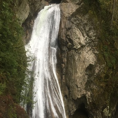
Twin Falls (Olallie State Park)
Twin Falls in Olallie State Park State Park is an easy, 3 mile round trip hike with just 500 ft in elevation gain. The trail goes along the South Fork Snoqualmie River with a short side trip to scenic waterfalls. For a challenge, continue past the upper falls along the Palouse to Cascades State Park Trail to Change Creek and Hall Point.
Getting there
Take Exit 34 off of I-90, turn right onto 468th Ave SE, and drive ~0.5 mile to SE 159th St. Turn left and continue another 0.5 mile to the Lower Twin Falls Trailhead parking lot at the road's end (620 ft).
On the Trail
Twin Falls
3.0 miles round trip, 500 feet of elevation gain, 1,000 ft high point
Hike the Twin Falls Trail along the South Fork of the Snoqualmie River. In 0.5 mile, the trail leaves the river and begins to climb. At 0.75 mile enjoy the first view of the lower falls from the ridge crest. At 1.0 mile, the spur trail to the right leads to an overlook with fantastic views of the lower falls. At ~1.5 mile reach the bridge that crosses the middle of the "stair step" upper falls and a short distance beyond the bridge, the overlook for the upper falls.
Hall Point
9.0 miles, 2,000 feet of elevation gain, 2,600 ft High point
Hike past the falls and up to the John Wayne Pioneer Trail. Travel east on the Palouse to Cascades State Park Trail (formerly John Wayne Trail) to the start of the Change Creek Trail. The Change Creek Trail goes up the ridge between Change and Hall Creeks. The trail is fairly steep and can be quite rugged in places, but is well-maintained and even signed. The adventurous can take a short side-trip to Ollalie Point and and another short side trip to Hall Point for exceptional views. From Hall Point, retrace the route back to the trailhead.
Information for Leaders
scheduling
This route/place allow multiple bookings to accommodate morning and afternoon sections of our programs. Please be sure that no activities schedule here overlap.
permits
The Mountaineers has a commercial use permit with Washington State Parks for all free and fee-based outings at state parks. Leaders should carry a print or digital copy of our commercial use permit to show rangers they may encounter.
- Suitable Activities: Day Hiking
- Seasons: Year-round
- Weather: View weather forecast
- Difficulty: Easy
- Length: 3.0 mi
- Elevation Gain: 500 ft
- 1,000 ft
- Land Manager: Olallie State Park
- Parking Permit Required: Discover Pass
- Recommended Party Size: 50
- Maximum Party Size: 50
- Maximum Route/Place Capacity: 12
- Green Trails Bandera No. 206
- Green Trails Mount Si NRCA No. 206S
- USGS Bandera
This is a list of titles that represent the variations of trips you can take at this route/place. This includes side trips, extensions and peak combinations. Not seeing a title that fits your trip? Log in and send us updates, images, or resources.
- Twin Falls
- Lower Twin Falls
- Upper Twin Falls
- Hall Point
- Twin Falls & Hall Point
There are no resources for this route/place. Log in and send us updates, images, or resources.
