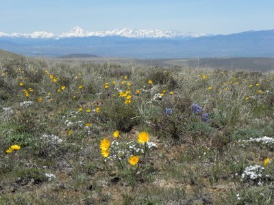
Umtanum Ridge
A trail that leads out of Yakima and Umtanum Canyons up to the top of Umtanum Ridge, offering views of Mount Stuart, Mount Rainier, Mount Adams, and Mount Hood.
getting there
Take Exit 3 off of I-82 and turn right onto SR 821. At the next stop sign turn left to stay on SR 821 and continue 8 miles to the Umtanum Recreation Area after Milepost 16. Park in the gravel lot west of the highway.
Parking: The parking lot is managed by the BLM (U.S. Department of the Interior's Bureau of Land Management). The day use parking fee may be paid at the self-service fee station. Visit the BLM Permits and Passes website for other options.
- Suitable Activities: Day Hiking
- Seasons: March, April, May, June, July
- Weather: View weather forecast
- Difficulty: Moderate
- Length: 6.0 mi
- Elevation Gain: 2,400 ft
- 3,600 ft
- Land Manager: Wenas Wildlife Area
- Parking Permit Required: BLM Permits & Passes
- Recommended Party Size: 12
- Maximum Party Size: 12
- Maximum Route/Place Capacity: 12
- USGS Selah
- USGS Pomona
- USGS Wymer
- WA DNR Yakima
- Green Dot Maps (wdfw.wa.gov)
This is a list of titles that represent the variations of trips you can take at this route/place. This includes side trips, extensions and peak combinations. Not seeing a title that fits your trip? Log in and send us updates, images, or resources.
- Umtanum Creek Canyon
There are no resources for this route/place. Log in and send us updates, images, or resources.
